Vermilion geodata
Vermilion (Ohio) is a populated place; located in United States in America/New_York (GMT-4) time zone. With population of 10,434 people, there are 4338 cities with bigger population in this country. Compared to other cities in United States, 70% of cities are located further ↓South; 64.4% of cities are located further ←West and 54.2% of cities have higher elevation than Vermilion. Note1


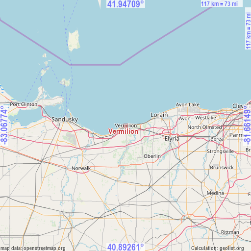
Vermilion GPS coordinates[2]
41° 25' 19.164" North, 82° 21' 52.596" West
| Map corner | latitude | longitude |
|---|---|---|
| Upper-left | 41.94709°, | -83.06774° |
| Center: | 41.42199°, | -82.36461° |
| Lower-right: | 40.89261°, | -81.66149° |
| Map W x H: | 117.2×117.2 km | = 72.8×72.8mi |
| max Lat: | 71.29058° ⇑30% North |
| Vermilion: | 41.42199° |
| min Lat: | ⇓70% South 19.06759° |
| min Long | Vermilion | max Long |
| -171.73463° | -82.36461° | -66.98998° |
| W 64.4%⇐ | ⇒35.6% E |
Elevation
Elevation of Vermilion is 183 m = 600 ft, and this is 111.8 m = 367 ft below average elevation for this country.
| Max E: |
3189 m = 10463 ft | 54.2% |
| Avg. | 294.8 m = 967 ft | |
| Vermilion | 183 m = 600 ft | |
Min E: |
-60 m = -197 ft | 45.8% |
See also: United States elevation on elevation.city.
Geographical zone
Vermilion is located in North temperate zone (between Tropic of Cancer and the Arctic Circle). Distance of this Northern Tropic circle is 1999.8 km =1242.6 mi to South.| Distance of | km | miles | from Vermilion |
|---|---|---|---|
| North Pole | 5401.4 | 3356.3 | to North |
| Arctic Circle | 2795.5 | 1737 | to North |
| Tropic Cancer | 1999.8 | 1242.6 | to South |
| Equator | 4605.7 | 2861.8 | to South |


Nearby cities:
15 places around Vermilion: (largest is in red/bold)
• Amherst
12.2 km =7.6 mi,  102°
102°
• Berlin Heights
15.2 km =9.4 mi,  224°
224°
• Camden
21.1 km =13.1 mi,  166°
166°
• Collins
21 km =13 mi,  210°
210°
• Elyria
22.2 km =13.8 mi,  105°
105°
• Huron
16.2 km =10.1 mi,  259°
259°
• Lorain
15.6 km =9.7 mi,  77°
77°
• Milan
24.4 km =15.2 mi,  235°
235°
• Oberlin
18.8 km =11.7 mi,  139°
139°
• Sheffield
22.4 km =13.9 mi,  90°
90°
• Sheffield
22.6 km =14 mi, 78°
• Sheffield Lake
23.1 km =14.4 mi,  71°
71°
• South Amherst
11.8 km =7.3 mi,  128°
128°
• Vermilion-on-the-Lake
3.5 km =2.2 mi, 78°
• Wakeman
18.9 km =11.7 mi,  188°
188°
Sources, notices
• [Note1] Compared only with cities in United States existing in our database
• [Src1] Map data: © OpenStreetMap contributors (CC-BY-SA)
• [Src2] Other city data from geonames.org with taken over terms of usage.
• [Src3] Geographical zone / Annual Mean Temperature by Robert A. Rohde @ Wikipedia
