Sheffield Lake geodata
Sheffield Lake (Ohio) is a populated place; located in United States in America/New_York (GMT-4) time zone. With population of 9,026 people, there are 4798 cities with bigger population in this country. Compared to other cities in United States, 70.7% of cities are located further ↓South; 65.2% of cities are located further ←West and 53.1% of cities have higher elevation than Sheffield Lake. Note1


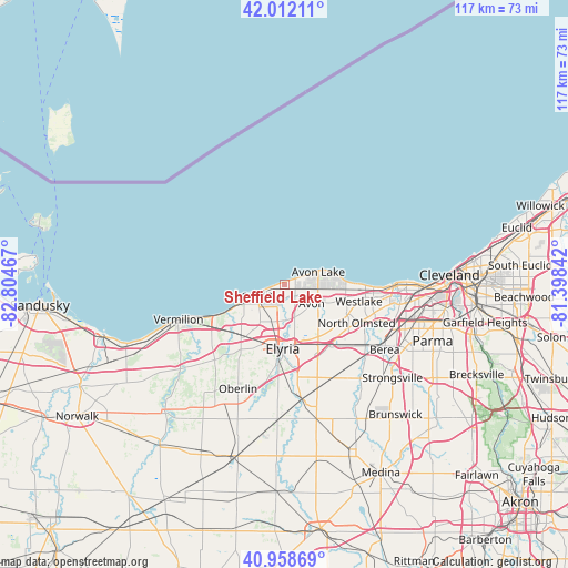
Sheffield Lake GPS coordinates[2]
41° 29' 15.144" North, 82° 6' 5.544" West
| Map corner | latitude | longitude |
|---|---|---|
| Upper-left | 42.01211°, | -82.80467° |
| Center: | 41.48754°, | -82.10154° |
| Lower-right: | 40.95869°, | -81.39842° |
| Map W x H: | 117.1×117.1 km | = 72.8×72.8mi |
| max Lat: | 71.29058° ⇑29.3% North |
| Sheffield Lake: | 41.48754° |
| min Lat: | ⇓70.7% South 19.06759° |
| min Long | Sheffield Lake | max Long |
| -171.73463° | -82.10154° | -66.98998° |
| W 65.2%⇐ | ⇒34.8% E |
Elevation
Elevation of Sheffield Lake is 187 m = 614 ft, and this is 107.8 m = 354 ft below average elevation for this country.
| Max E: |
3189 m = 10463 ft | 53.1% |
| Avg. | 294.8 m = 967 ft | |
| Sheffield Lake | 187 m = 614 ft | |
Min E: |
-60 m = -197 ft | 46.9% |
See also: United States elevation on elevation.city.
Geographical zone
Sheffield Lake is located in North temperate zone (between Tropic of Cancer and the Arctic Circle). Distance of this Northern Tropic circle is 2007.1 km =1247.2 mi to South.| Distance of | km | miles | from Sheffield Lake |
|---|---|---|---|
| North Pole | 5394.1 | 3351.7 | to North |
| Arctic Circle | 2788.2 | 1732.5 | to North |
| Tropic Cancer | 2007.1 | 1247.2 | to South |
| Equator | 4613 | 2866.4 | to South |


Nearby cities:
15 places around Sheffield Lake: (largest is in red/bold)
• Amherst
14.2 km =8.8 mi,  225°
225°
• Avon
6.8 km =4.2 mi,  125°
125°
• Avon Center
7.5 km =4.7 mi,  114°
114°
• Avon Lake
6.4 km =4 mi,  72°
72°
• Bay Village
15 km =9.3 mi,  91°
91°
• Elyria
13.3 km =8.3 mi,  182°
182°
• Fairview Park
20.4 km =12.7 mi,  104°
104°
• Lorain
7.8 km =4.8 mi,  240°
240°
• North Olmsted
16.9 km =10.5 mi,  118°
118°
• North Ridgeville
12.9 km =8 mi,  147°
147°
• Sheffield
2.8 km =1.7 mi, 175°
• Sheffield
7.4 km =4.6 mi, 176°
• South Amherst
19.4 km =12.1 mi,  220°
220°
• Vermilion-on-the-Lake
19.7 km =12.2 mi,  250°
250°
• Westlake
15.7 km =9.8 mi, 103°
Sources, notices
• [Note1] Compared only with cities in United States existing in our database
• [Src1] Map data: © OpenStreetMap contributors (CC-BY-SA)
• [Src2] Other city data from geonames.org with taken over terms of usage.
• [Src3] Geographical zone / Annual Mean Temperature by Robert A. Rohde @ Wikipedia
