Lorain geodata
Lorain (Ohio) is a populated place; located in United States in America/New_York (GMT-4) time zone. With population of 63,647 people, there are 682 cities with bigger population in this country. Compared to other cities in United States, 70.3% of cities are located further ↓South; 65% of cities are located further ←West and 53.1% of cities have higher elevation than Lorain. Note1


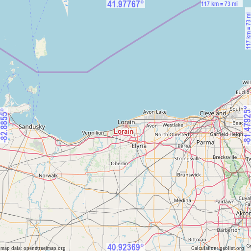
Lorain GPS coordinates[2]
41° 27' 10.152" North, 82° 10' 56.532" West
| Map corner | latitude | longitude |
|---|---|---|
| Upper-left | 41.97767°, | -82.8855° |
| Center: | 41.45282°, | -82.18237° |
| Lower-right: | 40.92369°, | -81.47925° |
| Map W x H: | 117.2×117.2 km | = 72.8×72.8mi |
| max Lat: | 71.29058° ⇑29.7% North |
| Lorain: | 41.45282° |
| min Lat: | ⇓70.3% South 19.06759° |
| min Long | Lorain | max Long |
| -171.73463° | -82.18237° | -66.98998° |
| W 65%⇐ | ⇒35% E |
Elevation
Elevation of Lorain is 187 m = 614 ft, and this is 107.8 m = 354 ft below average elevation for this country.
| Max E: |
3189 m = 10463 ft | 53.1% |
| Avg. | 294.8 m = 967 ft | |
| Lorain | 187 m = 614 ft | |
Min E: |
-60 m = -197 ft | 46.9% |
See also: Lorain elevation on elevation.city.
Geographical zone
Lorain is located in North temperate zone (between Tropic of Cancer and the Arctic Circle). Distance of this Northern Tropic circle is 2003.2 km =1244.7 mi to South.| Distance of | km | miles | from Lorain |
|---|---|---|---|
| North Pole | 5397.9 | 3354.1 | to North |
| Arctic Circle | 2792.1 | 1734.9 | to North |
| Tropic Cancer | 2003.2 | 1244.7 | to South |
| Equator | 4609.1 | 2864 | to South |


Nearby cities:
15 places around Lorain: (largest is in red/bold)
• Amherst
7 km =4.3 mi,  208°
208°
• Avon
12.2 km =7.6 mi,  90°
90°
• Avon Center
13.6 km =8.5 mi, 86°
• Avon Lake
14.1 km =8.8 mi,  65°
65°
• Bay Village
22 km =13.7 mi,  80°
80°
• Eaton Estates
21.8 km =13.5 mi,  137°
137°
• Elyria
11.3 km =7 mi,  146°
146°
• North Ridgeville
15.3 km =9.5 mi,  117°
117°
• Oberlin
17.9 km =11.1 mi,  189°
189°
• Sheffield
7.1 km =4.4 mi, 81°
• Sheffield
8 km =5 mi, 116°
• Sheffield Lake
7.8 km =4.8 mi,  60°
60°
• South Amherst
12.3 km =7.6 mi, 208°
• Vermilion
15.6 km =9.7 mi,  257°
257°
• Vermilion-on-the-Lake
12.1 km =7.5 mi, 257°
Sources, notices
• [Note1] Compared only with cities in United States existing in our database
• [Src1] Map data: © OpenStreetMap contributors (CC-BY-SA)
• [Src2] Other city data from geonames.org with taken over terms of usage.
• [Src3] Geographical zone / Annual Mean Temperature by Robert A. Rohde @ Wikipedia
