Webster geodata
Webster (South Dakota) is a seat of a second-order administrative division; located in United States in America/Chicago (GMT-5) time zone. With population of 1,802 people, there are 12532 cities with bigger population in this country. Compared to other cities in United States, 93.5% of cities are located further ↓South; 77.2% of cities are located further →East and 89.1% of cities have lower elevation than Webster. Note1


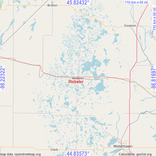
Webster GPS coordinates[2]
45° 19' 55.848" North, 97° 31' 12.324" West
| Map corner | latitude | longitude |
|---|---|---|
| Upper-left | 45.82432°, | -98.22322° |
| Center: | 45.33218°, | -97.52009° |
| Lower-right: | 44.83573°, | -96.81697° |
| Map W x H: | 109.9×109.9 km | = 68.3×68.3mi |
| max Lat: | 71.29058° ⇑6.5% North |
| Webster: | 45.33218° |
| min Lat: | ⇓93.5% South 19.06759° |
| min Long | Webster | max Long |
| -171.73463° | -97.52009° | -66.98998° |
| W 22.8%⇐ | ⇒77.2% E |
Elevation
Elevation of Webster is 565 m = 1854 ft, and this is 270.2 m = 886 ft above average elevation for this country.
| Max E: |
3189 m = 10463 ft | 10.9% |
| Webster | 565 m 1854 ft | |
| Avg. | 294.8 m = 967 ft | |
Min E: |
-60 m = -197 ft | 89.1% |
See also: United States elevation on elevation.city.
Geographical zone
Webster is located in North temperate zone (between Tropic of Cancer and the Arctic Circle). Distance of this North polar circle is 2360.7 km =1466.9 mi to North.| Distance of | km | miles | from Webster |
|---|---|---|---|
| North Pole | 4966.6 | 3086.1 | to North |
| Arctic Circle | 2360.7 | 1466.9 | to North |
| Tropic Cancer | 2434.5 | 1512.7 | to South |
| Equator | 5040.5 | 3132 | to South |


Nearby cities:
15 places around Webster: (largest is in red/bold)
• Aberdeen
76.9 km =47.8 mi,  281°
281°
• Britton
54.2 km =33.7 mi,  340°
340°
• Browns Valley
61 km =37.9 mi,  61°
61°
• Castlewood
77.9 km =48.4 mi,  150°
150°
• Clark
53.2 km =33.1 mi,  198°
198°
• Goodwill
43.7 km =27.2 mi,  53°
53°
• Groton
47 km =29.2 mi,  285°
285°
• Hayti
79 km =49.1 mi,  161°
161°
• Milbank
70.3 km =43.7 mi,  100°
100°
• Ortonville
84.1 km =52.3 mi,  92°
92°
• Sisseton
52.1 km =32.4 mi,  44°
44°
• Veblen
61.7 km =38.3 mi,  17°
17°
• Watertown
57.7 km =35.9 mi, 146°
• Waubay
16.8 km =10.4 mi, 90°
• Wilmot
52.4 km =32.6 mi,  80°
80°
Sources, notices
• [Note1] Compared only with cities in United States existing in our database
• [Src1] Map data: © OpenStreetMap contributors (CC-BY-SA)
• [Src2] Other city data from geonames.org with taken over terms of usage.
• [Src3] Geographical zone / Annual Mean Temperature by Robert A. Rohde @ Wikipedia
