Tomah geodata
Tomah (Wisconsin) is a populated place; located in United States in America/Chicago (GMT-5) time zone. With population of 9,357 people, there are 4664 cities with bigger population in this country. Compared to other cities in United States, 88.3% of cities are located further ↓South; 60.9% of cities are located further →East and 72.2% of cities have lower elevation than Tomah. Note1


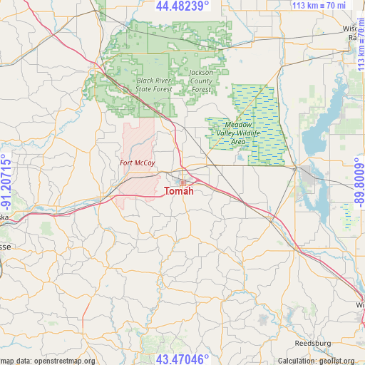
Tomah GPS coordinates[2]
43° 58' 42.888" North, 90° 30' 14.472" West
| Map corner | latitude | longitude |
|---|---|---|
| Upper-left | 44.48239°, | -91.20715° |
| Center: | 43.97858°, | -90.50402° |
| Lower-right: | 43.47046°, | -89.8009° |
| Map W x H: | 112.5×112.5 km | = 69.9×69.9mi |
| max Lat: | 71.29058° ⇑11.7% North |
| Tomah: | 43.97858° |
| min Lat: | ⇓88.3% South 19.06759° |
| min Long | Tomah | max Long |
| -171.73463° | -90.50402° | -66.98998° |
| W 39.1%⇐ | ⇒60.9% E |
Elevation
Elevation of Tomah is 297 m = 974 ft, and this is 2.2 m = 7 ft above average elevation for this country.
| Max E: |
3189 m = 10463 ft | 27.8% |
| Tomah | 297 m 974 ft | |
| Avg. | 294.8 m = 967 ft | |
Min E: |
-60 m = -197 ft | 72.2% |
See also: United States elevation on elevation.city.
Geographical zone
Tomah is located in North temperate zone (between Tropic of Cancer and the Arctic Circle). Distance of this Northern Tropic circle is 2284 km =1419.2 mi to South.| Distance of | km | miles | from Tomah |
|---|---|---|---|
| North Pole | 5117.1 | 3179.6 | to North |
| Arctic Circle | 2511.2 | 1560.4 | to North |
| Tropic Cancer | 2284 | 1419.2 | to South |
| Equator | 4890 | 3038.5 | to South |


Nearby cities:
15 places around Tomah: (largest is in red/bold)
• Bangor
40.1 km =24.9 mi,  256°
256°
• Camp Douglas
19.6 km =12.2 mi,  108°
108°
• Cashton
34.3 km =21.3 mi,  219°
219°
• Elroy
32.3 km =20.1 mi,  144°
144°
• Hillsboro
38.5 km =23.9 mi,  160°
160°
• Mauston
39.7 km =24.7 mi,  120°
120°
• Necedah
34.8 km =21.6 mi,  81°
81°
• New Lisbon
29.3 km =18.2 mi, 112°
• Norwalk
19 km =11.8 mi,  209°
209°
• Ontario
29 km =18 mi,  194°
194°
• Portland
36.7 km =22.8 mi,  230°
230°
• Rockland
34.2 km =21.3 mi, 256°
• Sparta
25 km =15.5 mi, 261°
• Wilton
18.4 km =11.4 mi, 185°
• Wonewoc
42.7 km =26.5 mi,  148°
148°
Sources, notices
• [Note1] Compared only with cities in United States existing in our database
• [Src1] Map data: © OpenStreetMap contributors (CC-BY-SA)
• [Src2] Other city data from geonames.org with taken over terms of usage.
• [Src3] Geographical zone / Annual Mean Temperature by Robert A. Rohde @ Wikipedia
