Leoti geodata
Leoti (Kansas) is a seat of a second-order administrative division; located in United States in America/Chicago (GMT-5) time zone. With population of 1,484 people, there are 13729 cities with bigger population in this country. Compared to other cities in United States, 58.9% of cities are located further ↑North; 81.5% of cities are located further →East and 93.5% of cities have lower elevation than Leoti. Note1


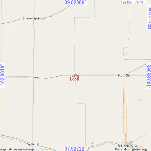
Leoti GPS coordinates[2]
38° 28' 47.064" North, 101° 21' 31.572" West
| Map corner | latitude | longitude |
|---|---|---|
| Upper-left | 39.02806°, | -102.0619° |
| Center: | 38.47974°, | -101.35877° |
| Lower-right: | 37.92722°, | -100.65565° |
| Map W x H: | 122.4×122.4 km | = 76.1×76.1mi |
| max Lat: | 71.29058° ⇑58.9% North |
| Leoti: | 38.47974° |
| min Lat: | ⇓41.1% South 19.06759° |
| min Long | Leoti | max Long |
| -171.73463° | -101.35877° | -66.98998° |
| W 18.5%⇐ | ⇒81.5% E |
Elevation
Elevation of Leoti is 1014 m = 3327 ft, and this is 719.2 m = 2360 ft above average elevation for this country.
| Max E: |
3189 m = 10463 ft | 6.5% |
| Leoti | 1014 m 3327 ft | |
| Avg. | 294.8 m = 967 ft | |
Min E: |
-60 m = -197 ft | 93.5% |
See also: United States elevation on elevation.city.
Geographical zone
Leoti is located in North temperate zone (between Tropic of Cancer and the Arctic Circle). Distance of this Northern Tropic circle is 1672.6 km =1039.3 mi to South.| Distance of | km | miles | from Leoti |
|---|---|---|---|
| North Pole | 5728.5 | 3559.5 | to North |
| Arctic Circle | 3122.6 | 1940.3 | to North |
| Tropic Cancer | 1672.6 | 1039.3 | to South |
| Equator | 4278.5 | 2658.5 | to South |


Nearby cities:
15 places around Leoti: (largest is in red/bold)
• Cheyenne Wells
94.3 km =58.6 mi,  293°
293°
• Deerfield
59 km =36.7 mi,  160°
160°
• Dighton
77.6 km =48.2 mi,  89°
89°
• Garden City
70.7 km =43.9 mi,  143°
143°
• Goodland
101.5 km =63.1 mi,  342°
342°
• Gove
92.3 km =57.4 mi,  54°
54°
• Holcomb
63.7 km =39.6 mi,  149°
149°
• Holly
81.9 km =50.9 mi,  234°
234°
• Lakin
60.6 km =37.7 mi,  171°
171°
• Oakley
84.4 km =52.4 mi,  30°
30°
• Scott City
39.3 km =24.4 mi, 89°
• Sharon Springs
57.7 km =35.9 mi,  323°
323°
• Syracuse
65.4 km =40.6 mi,  211°
211°
• Tribune
34.3 km =21.3 mi,  268°
268°
• Ulysses
99.9 km =62.1 mi,  179°
179°
Sources, notices
• [Note1] Compared only with cities in United States existing in our database
• [Src1] Map data: © OpenStreetMap contributors (CC-BY-SA)
• [Src2] Other city data from geonames.org with taken over terms of usage.
• [Src3] Geographical zone / Annual Mean Temperature by Robert A. Rohde @ Wikipedia
