Eloy geodata
Eloy (Arizona) is a populated place; located in United States in America/Phoenix (GMT-7) time zone. With population of 17,059 people, there are 2894 cities with bigger population in this country. Compared to other cities in United States, 86.2% of cities are located further ↑North; 86.7% of cities are located further →East and 87.1% of cities have lower elevation than Eloy. Note1


Eloy GPS coordinates[2]
32° 45' 21.24" North, 111° 33' 17.424" West
| Map corner | latitude | longitude |
|---|---|---|
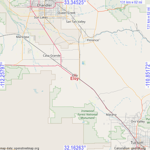
| Upper-left | 33.34525°, | -112.25797° |
| Center: | 32.7559°, | -111.55484° |
| Lower-right: | 32.16263°, | -110.85172° |
| Map W x H: | 131.5×131.5 km | = 81.7×81.7mi |
| max Lat: | 71.29058° ⇑86.2% North |
| Eloy: | 32.7559° |
| min Lat: | ⇓13.8% South 19.06759° |
| min Long | Eloy | max Long |
| -171.73463° | -111.55484° | -66.98998° |
| W 13.3%⇐ | ⇒86.7% E |
Elevation
Elevation of Eloy is 472 m = 1549 ft, and this is 177.2 m = 581 ft above average elevation for this country.
| Max E: |
3189 m = 10463 ft | 12.9% |
| Eloy | 472 m 1549 ft | |
| Avg. | 294.8 m = 967 ft | |
Min E: |
-60 m = -197 ft | 87.1% |
See also: United States elevation on elevation.city.
Geographical zone
Eloy is located in North temperate zone (between Tropic of Cancer and the Arctic Circle). Distance of this Northern Tropic circle is 1036.2 km =643.9 mi to South.| Distance of | km | miles | from Eloy |
|---|---|---|---|
| North Pole | 6364.9 | 3955 | to North |
| Arctic Circle | 3759.1 | 2335.8 | to North |
| Tropic Cancer | 1036.2 | 643.9 | to South |
| Equator | 3642.1 | 2263.1 | to South |


Nearby cities:
15 places around Eloy: (largest is in red/bold)
• Arizona City
10.9 km =6.8 mi,  269°
269°
• Avra Valley
41.9 km =26 mi,  147°
147°
• Blackwater
30.7 km =19.1 mi,  355°
355°
• Cactus Forest
31.6 km =19.6 mi,  44°
44°
• Casa Blanca
51.1 km =31.8 mi,  322°
322°
• Casa Grande
23.4 km =14.5 mi,  305°
305°
• Coolidge
24.9 km =15.5 mi,  8°
8°
• Florence
34.4 km =21.4 mi,  27°
27°
• Marana
47 km =29.2 mi,  138°
138°
• Picture Rocks
54 km =33.6 mi, 147°
• Queen Creek
55.3 km =34.4 mi,  352°
352°
• Sacaton
39.6 km =24.6 mi,  334°
334°
• San Tan Valley
48.5 km =30.1 mi,  2°
2°
• Santan
52 km =32.3 mi, 333°
• Stanfield
40.6 km =25.2 mi,  290°
290°
Sources, notices
• [Note1] Compared only with cities in United States existing in our database
• [Src1] Map data: © OpenStreetMap contributors (CC-BY-SA)
• [Src2] Other city data from geonames.org with taken over terms of usage.
• [Src3] Geographical zone / Annual Mean Temperature by Robert A. Rohde @ Wikipedia
