Coolidge geodata
Coolidge (Arizona) is a populated place; located in United States in America/Phoenix (GMT-7) time zone. With population of 12,297 people, there are 3824 cities with bigger population in this country. Compared to other cities in United States, 85.2% of cities are located further ↑North; 86.6% of cities are located further →East and 85.5% of cities have lower elevation than Coolidge. Note1


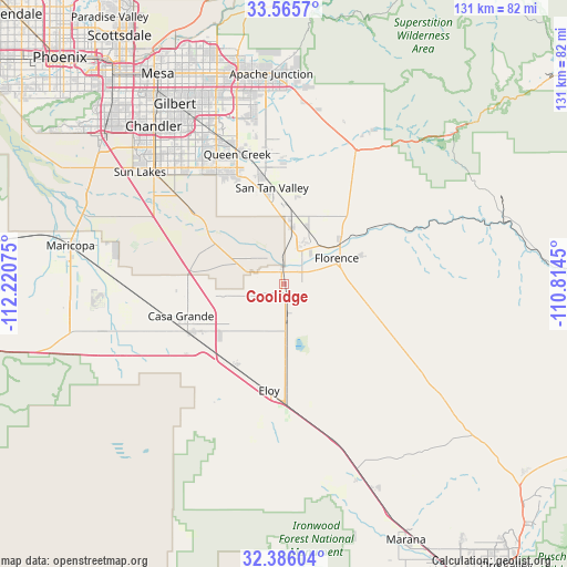
Coolidge GPS coordinates[2]
32° 58' 40.224" North, 111° 31' 3.432" West
| Map corner | latitude | longitude |
|---|---|---|
| Upper-left | 33.5657°, | -112.22075° |
| Center: | 32.97784°, | -111.51762° |
| Lower-right: | 32.38604°, | -110.8145° |
| Map W x H: | 131.2×131.2 km | = 81.5×81.5mi |
| max Lat: | 71.29058° ⇑85.2% North |
| Coolidge: | 32.97784° |
| min Lat: | ⇓14.8% South 19.06759° |
| min Long | Coolidge | max Long |
| -171.73463° | -111.51762° | -66.98998° |
| W 13.4%⇐ | ⇒86.6% E |
Elevation
Elevation of Coolidge is 433 m = 1421 ft, and this is 138.2 m = 453 ft above average elevation for this country.
| Max E: |
3189 m = 10463 ft | 14.5% |
| Coolidge | 433 m 1421 ft | |
| Avg. | 294.8 m = 967 ft | |
Min E: |
-60 m = -197 ft | 85.5% |
See also: United States elevation on elevation.city.
Geographical zone
Coolidge is located in North temperate zone (between Tropic of Cancer and the Arctic Circle). Distance of this Northern Tropic circle is 1060.9 km =659.2 mi to South.| Distance of | km | miles | from Coolidge |
|---|---|---|---|
| North Pole | 6340.3 | 3939.7 | to North |
| Arctic Circle | 3734.4 | 2320.4 | to North |
| Tropic Cancer | 1060.9 | 659.2 | to South |
| Equator | 3666.8 | 2278.4 | to South |


Nearby cities:
15 places around Coolidge: (largest is in red/bold)
• Arizona City
28.5 km =17.7 mi,  210°
210°
• Blackwater
8.5 km =5.3 mi,  314°
314°
• Cactus Forest
18.6 km =11.6 mi,  96°
96°
• Casa Blanca
38 km =23.6 mi,  294°
294°
• Casa Grande
24.9 km =15.5 mi,  243°
243°
• Eloy
24.9 km =15.5 mi,  188°
188°
• Florence
13.5 km =8.4 mi,  63°
63°
• Gold Camp
40.3 km =25 mi,  29°
29°
• Queen Creek
32 km =19.9 mi,  340°
340°
• Queen Valley
41.5 km =25.8 mi, 30°
• Sacaton
23.4 km =14.5 mi,  298°
298°
• San Tan Valley
23.7 km =14.7 mi,  357°
357°
• Santan
34.3 km =21.3 mi, 309°
• Stanfield
42.8 km =26.6 mi,  255°
255°
• Sun Lakes
42.2 km =26.2 mi, 307°
Sources, notices
• [Note1] Compared only with cities in United States existing in our database
• [Src1] Map data: © OpenStreetMap contributors (CC-BY-SA)
• [Src2] Other city data from geonames.org with taken over terms of usage.
• [Src3] Geographical zone / Annual Mean Temperature by Robert A. Rohde @ Wikipedia
