Santan geodata
Santan (Arizona) is a populated place; located in United States in America/Phoenix (GMT-7) time zone. With population of 883 people, there are 17089 cities with bigger population in this country. Compared to other cities in United States, 84.4% of cities are located further ↑North; 87% of cities are located further →East and 81.7% of cities have lower elevation than Santan. Note1


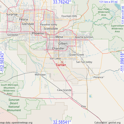
Santan GPS coordinates[2]
33° 10' 33.204" North, 111° 47' 57.48" West
| Map corner | latitude | longitude |
|---|---|---|
| Upper-left | 33.76242°, | -112.50243° |
| Center: | 33.17589°, | -111.7993° |
| Lower-right: | 32.58541°, | -111.09618° |
| Map W x H: | 130.9×130.9 km | = 81.3×81.3mi |
| max Lat: | 71.29058° ⇑84.4% North |
| Santan: | 33.17589° |
| min Lat: | ⇓15.6% South 19.06759° |
| min Long | Santan | max Long |
| -171.73463° | -111.7993° | -66.98998° |
| W 13%⇐ | ⇒87% E |
Elevation
Elevation of Santan is 373 m = 1224 ft, and this is 78.2 m = 257 ft above average elevation for this country.
| Max E: |
3189 m = 10463 ft | 18.3% |
| Santan | 373 m 1224 ft | |
| Avg. | 294.8 m = 967 ft | |
Min E: |
-60 m = -197 ft | 81.7% |
See also: United States elevation on elevation.city.
Geographical zone
Santan is located in North temperate zone (between Tropic of Cancer and the Arctic Circle). Distance of this Northern Tropic circle is 1082.9 km =672.9 mi to South.| Distance of | km | miles | from Santan |
|---|---|---|---|
| North Pole | 6318.2 | 3925.9 | to North |
| Arctic Circle | 3712.4 | 2306.8 | to North |
| Tropic Cancer | 1082.9 | 672.9 | to South |
| Equator | 3688.8 | 2292.1 | to South |


Nearby cities:
15 places around Santan: (largest is in red/bold)
• Ahwatukee Foothills
25.2 km =15.7 mi,  317°
317°
• Blackwater
25.8 km =16 mi,  128°
128°
• Casa Blanca
10.3 km =6.4 mi,  233°
233°
• Chandler
15 km =9.3 mi,  344°
344°
• Gilbert
19.7 km =12.2 mi,  2°
2°
• Guadalupe
26.5 km =16.5 mi, 324°
• Maricopa
26.6 km =16.5 mi,  240°
240°
• Mesa
27.5 km =17.1 mi,  355°
355°
• Queen Creek
17.4 km =10.8 mi,  62°
62°
• Sacaton
12.4 km =7.7 mi,  153°
153°
• San Carlos
19.5 km =12.1 mi,  345°
345°
• San Tan Valley
25.3 km =15.7 mi,  86°
86°
• Sun Lakes
8.1 km =5 mi,  298°
298°
• Tempe
28.5 km =17.7 mi, 338°
• Tempe Junction
29.7 km =18.5 mi,  333°
333°
Sources, notices
• [Note1] Compared only with cities in United States existing in our database
• [Src1] Map data: © OpenStreetMap contributors (CC-BY-SA)
• [Src2] Other city data from geonames.org with taken over terms of usage.
• [Src3] Geographical zone / Annual Mean Temperature by Robert A. Rohde @ Wikipedia
