Sun Lakes geodata
Sun Lakes (Arizona) is a populated place; located in United States in America/Phoenix (GMT-7) time zone. With population of 13,975 people, there are 3442 cities with bigger population in this country. Compared to other cities in United States, 84.3% of cities are located further ↑North; 87.2% of cities are located further →East and 80.8% of cities have lower elevation than Sun Lakes. Note1


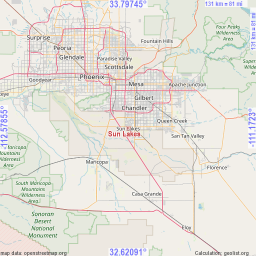
Sun Lakes GPS coordinates[2]
33° 12' 40.176" North, 111° 52' 31.512" West
| Map corner | latitude | longitude |
|---|---|---|
| Upper-left | 33.79745°, | -112.57855° |
| Center: | 33.21116°, | -111.87542° |
| Lower-right: | 32.62091°, | -111.1723° |
| Map W x H: | 130.8×130.8 km | = 81.3×81.3mi |
| max Lat: | 71.29058° ⇑84.3% North |
| Sun Lakes: | 33.21116° |
| min Lat: | ⇓15.7% South 19.06759° |
| min Long | Sun Lakes | max Long |
| -171.73463° | -111.87542° | -66.98998° |
| W 12.8%⇐ | ⇒87.2% E |
Elevation
Elevation of Sun Lakes is 362 m = 1188 ft, and this is 67.2 m = 220 ft above average elevation for this country.
| Max E: |
3189 m = 10463 ft | 19.2% |
| Sun Lakes | 362 m 1188 ft | |
| Avg. | 294.8 m = 967 ft | |
Min E: |
-60 m = -197 ft | 80.8% |
See also: United States elevation on elevation.city.
Geographical zone
Sun Lakes is located in North temperate zone (between Tropic of Cancer and the Arctic Circle). Distance of this Northern Tropic circle is 1086.8 km =675.3 mi to South.| Distance of | km | miles | from Sun Lakes |
|---|---|---|---|
| North Pole | 6314.3 | 3923.5 | to North |
| Arctic Circle | 3708.4 | 2304.3 | to North |
| Tropic Cancer | 1086.8 | 675.3 | to South |
| Equator | 3692.7 | 2294.5 | to South |


Nearby cities:
15 places around Sun Lakes: (largest is in red/bold)
• Ahwatukee Foothills
17.7 km =11 mi,  325°
325°
• Ak-Chin Village
28.3 km =17.6 mi,  224°
224°
• Casa Blanca
10.2 km =6.3 mi,  186°
186°
• Chandler
11 km =6.8 mi,  16°
16°
• Gila Crossing
28.1 km =17.5 mi,  285°
285°
• Gilbert
17.7 km =11 mi,  27°
27°
• Guadalupe
19.5 km =12.1 mi,  335°
335°
• Maricopa
23.4 km =14.5 mi, 223°
• Mesa
24 km =14.9 mi,  11°
11°
• Queen Creek
22.8 km =14.2 mi,  79°
79°
• Sacaton
19.6 km =12.2 mi,  139°
139°
• San Carlos
15.2 km =9.4 mi, 8°
• Santan
8.1 km =5 mi,  118°
118°
• Tempe
22.9 km =14.2 mi,  352°
352°
• Tempe Junction
23.4 km =14.5 mi, 344°
Sources, notices
• [Note1] Compared only with cities in United States existing in our database
• [Src1] Map data: © OpenStreetMap contributors (CC-BY-SA)
• [Src2] Other city data from geonames.org with taken over terms of usage.
• [Src3] Geographical zone / Annual Mean Temperature by Robert A. Rohde @ Wikipedia
