Barstow Heights geodata
Barstow Heights (California) is a populated place; located in United States in America/Los_Angeles (GMT-7) time zone. With population of 24,202 people, there are 2084 cities with bigger population in this country. Compared to other cities in United States, 76.1% of cities are located further ↑North; 89.8% of cities are located further →East and 91.8% of cities have lower elevation than Barstow Heights. Note1


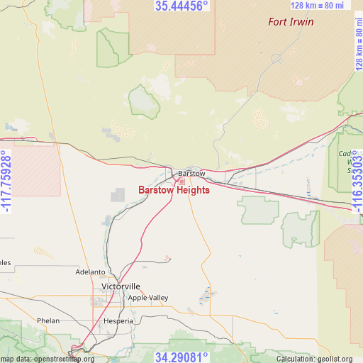
Barstow Heights GPS coordinates[2]
34° 52' 10.956" North, 117° 3' 22.14" West
| Map corner | latitude | longitude |
|---|---|---|
| Upper-left | 35.44456°, | -117.75928° |
| Center: | 34.86971°, | -117.05615° |
| Lower-right: | 34.29081°, | -116.35303° |
| Map W x H: | 128.3×128.3 km | = 79.7×79.7mi |
| max Lat: | 71.29058° ⇑76.1% North |
| Barstow Heights: | 34.86971° |
| min Lat: | ⇓23.9% South 19.06759° |
| min Long | Barstow Heights | max Long |
| -171.73463° | -117.05615° | -66.98998° |
| W 10.2%⇐ | ⇒89.8% E |
Elevation
Elevation of Barstow Heights is 780 m = 2559 ft, and this is 485.2 m = 1592 ft above average elevation for this country.
| Max E: |
3189 m = 10463 ft | 8.2% |
| Barstow Heights | 780 m 2559 ft | |
| Avg. | 294.8 m = 967 ft | |
Min E: |
-60 m = -197 ft | 91.8% |
See also: United States elevation on elevation.city.
Geographical zone
Barstow Heights is located in North temperate zone (between Tropic of Cancer and the Arctic Circle). Distance of this Northern Tropic circle is 1271.2 km =789.9 mi to South.| Distance of | km | miles | from Barstow Heights |
|---|---|---|---|
| North Pole | 6129.9 | 3808.9 | to North |
| Arctic Circle | 3524 | 2189.7 | to North |
| Tropic Cancer | 1271.2 | 789.9 | to South |
| Equator | 3877.1 | 2409.1 | to South |


Nearby cities:
15 places around Barstow Heights: (largest is in red/bold)
• Adelanto
45.4 km =28.2 mi,  225°
225°
• Apple Valley
42.7 km =26.5 mi,  196°
196°
• Barstow
4.4 km =2.7 mi,  43°
43°
• Boron
56 km =34.8 mi,  284°
284°
• Fort Irwin
55.2 km =34.3 mi, 37°
• Hesperia
54.1 km =33.6 mi, 204°
• Lake Arrowhead
70.2 km =43.6 mi,  190°
190°
• Lenwood
4.4 km =2.7 mi, 280°
• Lucerne Valley
48 km =29.8 mi,  170°
170°
• Mountain View Acres
49.4 km =30.7 mi,  212°
212°
• Oak Hills
61.7 km =38.3 mi, 208°
• Phelan
68.3 km =42.4 mi,  223°
223°
• Silver Lakes
29.4 km =18.3 mi,  242°
242°
• Spring Valley Lake
46.1 km =28.6 mi, 204°
• Victorville
42.9 km =26.7 mi, 210°
Sources, notices
• [Note1] Compared only with cities in United States existing in our database
• [Src1] Map data: © OpenStreetMap contributors (CC-BY-SA)
• [Src2] Other city data from geonames.org with taken over terms of usage.
• [Src3] Geographical zone / Annual Mean Temperature by Robert A. Rohde @ Wikipedia
