Adelanto geodata
Adelanto (California) is a populated place; located in United States in America/Los_Angeles (GMT-7) time zone. With population of 33,166 people, there are 1495 cities with bigger population in this country. Compared to other cities in United States, 77.3% of cities are located further ↑North; 90.3% of cities are located further →East and 92.6% of cities have lower elevation than Adelanto. Note1


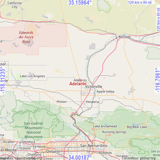
Adelanto GPS coordinates[2]
34° 34' 57.972" North, 117° 24' 33.192" West
| Map corner | latitude | longitude |
|---|---|---|
| Upper-left | 35.15964°, | -118.11235° |
| Center: | 34.58277°, | -117.40922° |
| Lower-right: | 34.00187°, | -116.7061° |
| Map W x H: | 128.7×128.7 km | = 80×80mi |
| max Lat: | 71.29058° ⇑77.3% North |
| Adelanto: | 34.58277° |
| min Lat: | ⇓22.7% South 19.06759° |
| min Long | Adelanto | max Long |
| -171.73463° | -117.40922° | -66.98998° |
| W 9.7%⇐ | ⇒90.3% E |
Elevation
Elevation of Adelanto is 881 m = 2890 ft, and this is 586.2 m = 1923 ft above average elevation for this country.
| Max E: |
3189 m = 10463 ft | 7.4% |
| Adelanto | 881 m 2890 ft | |
| Avg. | 294.8 m = 967 ft | |
Min E: |
-60 m = -197 ft | 92.6% |
See also: United States elevation on elevation.city.
Geographical zone
Adelanto is located in North temperate zone (between Tropic of Cancer and the Arctic Circle). Distance of this Northern Tropic circle is 1239.3 km =770.1 mi to South.| Distance of | km | miles | from Adelanto |
|---|---|---|---|
| North Pole | 6161.8 | 3828.8 | to North |
| Arctic Circle | 3555.9 | 2209.5 | to North |
| Tropic Cancer | 1239.3 | 770.1 | to South |
| Equator | 3845.2 | 2389.3 | to South |


Nearby cities:
15 places around Adelanto: (largest is in red/bold)
• Apple Valley
22.4 km =13.9 mi,  114°
114°
• Crestline
39.6 km =24.6 mi,  163°
163°
• Hesperia
20 km =12.4 mi,  150°
150°
• Lake Arrowhead
42.3 km =26.3 mi, 151°
• Lake Los Angeles
38.5 km =23.9 mi,  274°
274°
• Lenwood
43 km =26.7 mi,  40°
40°
• Lytle Creek
36.9 km =22.9 mi,  193°
193°
• Mountain View Acres
11.1 km =6.9 mi, 150°
• Oak Hills
22.3 km =13.9 mi,  173°
173°
• Phelan
22.9 km =14.2 mi,  220°
220°
• Piñon Hills
27.4 km =17 mi,  232°
232°
• Silver Lakes
19.1 km =11.9 mi,  19°
19°
• Spring Valley Lake
16.3 km =10.1 mi,  127°
127°
• Victorville
12 km =7.5 mi,  115°
115°
• Wrightwood
32.1 km =19.9 mi, 219°
Sources, notices
• [Note1] Compared only with cities in United States existing in our database
• [Src1] Map data: © OpenStreetMap contributors (CC-BY-SA)
• [Src2] Other city data from geonames.org with taken over terms of usage.
• [Src3] Geographical zone / Annual Mean Temperature by Robert A. Rohde @ Wikipedia
