Phelan geodata
Phelan (California) is a populated place; located in United States in America/Los_Angeles (GMT-7) time zone. With population of 14,304 people, there are 3377 cities with bigger population in this country. Compared to other cities in United States, 78% of cities are located further ↑North; 90.4% of cities are located further →East and 95% of cities have lower elevation than Phelan. Note1


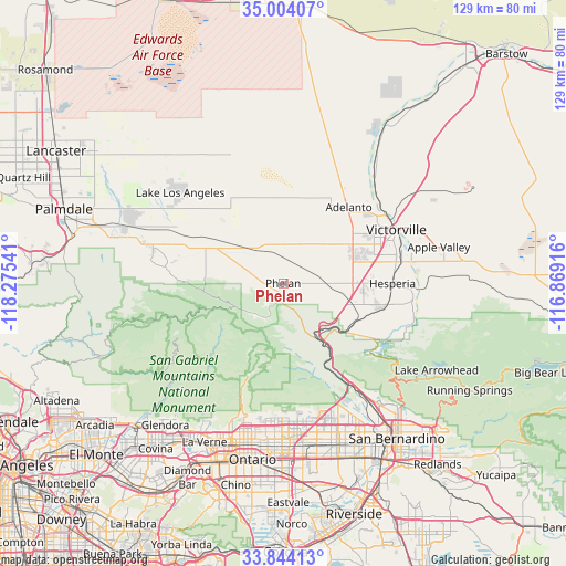
Phelan GPS coordinates[2]
34° 25' 33.996" North, 117° 34' 20.208" West
| Map corner | latitude | longitude |
|---|---|---|
| Upper-left | 35.00407°, | -118.27541° |
| Center: | 34.42611°, | -117.57228° |
| Lower-right: | 33.84413°, | -116.86916° |
| Map W x H: | 129×129 km | = 80.2×80.2mi |
| max Lat: | 71.29058° ⇑78% North |
| Phelan: | 34.42611° |
| min Lat: | ⇓22% South 19.06759° |
| min Long | Phelan | max Long |
| -171.73463° | -117.57228° | -66.98998° |
| W 9.6%⇐ | ⇒90.4% E |
Elevation
Elevation of Phelan is 1260 m = 4134 ft, and this is 965.2 m = 3167 ft above average elevation for this country.
| Max E: |
3189 m = 10463 ft | 5% |
| Phelan | 1260 m 4134 ft | |
| Avg. | 294.8 m = 967 ft | |
Min E: |
-60 m = -197 ft | 95% |
See also: United States elevation on elevation.city.
Geographical zone
Phelan is located in North temperate zone (between Tropic of Cancer and the Arctic Circle). Distance of this Northern Tropic circle is 1221.9 km =759.3 mi to South.| Distance of | km | miles | from Phelan |
|---|---|---|---|
| North Pole | 6179.2 | 3839.6 | to North |
| Arctic Circle | 3573.3 | 2220.3 | to North |
| Tropic Cancer | 1221.9 | 759.3 | to South |
| Equator | 3827.8 | 2378.5 | to South |


Nearby cities:
15 places around Phelan: (largest is in red/bold)
• Adelanto
22.9 km =14.2 mi,  40°
40°
• Apple Valley
36.4 km =22.6 mi,  76°
76°
• Crestline
33.3 km =20.7 mi,  127°
127°
• Hesperia
24.9 km =15.5 mi,  89°
89°
• Lake Los Angeles
31.3 km =19.4 mi,  311°
311°
• Lytle Creek
19.7 km =12.2 mi,  160°
160°
• Mountain View Acres
21.9 km =13.6 mi,  69°
69°
• Muscoy
36.8 km =22.9 mi,  145°
145°
• Oak Hills
18.2 km =11.3 mi,  105°
105°
• Piñon Hills
6.9 km =4.3 mi,  276°
276°
• Rancho Cucamonga
35.6 km =22.1 mi,  183°
183°
• San Antonio Heights
31.1 km =19.3 mi,  194°
194°
• Spring Valley Lake
28.9 km =18 mi, 74°
• Victorville
28.5 km =17.7 mi,  64°
64°
• Wrightwood
9.2 km =5.7 mi,  217°
217°
Sources, notices
• [Note1] Compared only with cities in United States existing in our database
• [Src1] Map data: © OpenStreetMap contributors (CC-BY-SA)
• [Src2] Other city data from geonames.org with taken over terms of usage.
• [Src3] Geographical zone / Annual Mean Temperature by Robert A. Rohde @ Wikipedia
