Victorville geodata
Victorville (California) is a populated place; located in United States in America/Los_Angeles (GMT-7) time zone. With population of 122,225 people, there are 256 cities with bigger population in this country. Compared to other cities in United States, 77.5% of cities are located further ↑North; 90.2% of cities are located further →East and 92.3% of cities have lower elevation than Victorville. Note1


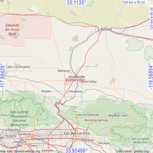
Victorville GPS coordinates[2]
34° 32' 9.996" North, 117° 17' 28.176" West
| Map corner | latitude | longitude |
|---|---|---|
| Upper-left | 35.1133°, | -117.99429° |
| Center: | 34.53611°, | -117.29116° |
| Lower-right: | 33.95489°, | -116.58804° |
| Map W x H: | 128.8×128.8 km | = 80×80mi |
| max Lat: | 71.29058° ⇑77.5% North |
| Victorville: | 34.53611° |
| min Lat: | ⇓22.5% South 19.06759° |
| min Long | Victorville | max Long |
| -171.73463° | -117.29116° | -66.98998° |
| W 9.8%⇐ | ⇒90.2% E |
Elevation
Elevation of Victorville is 834 m = 2736 ft, and this is 539.2 m = 1769 ft above average elevation for this country.
| Max E: |
3189 m = 10463 ft | 7.7% |
| Victorville | 834 m 2736 ft | |
| Avg. | 294.8 m = 967 ft | |
Min E: |
-60 m = -197 ft | 92.3% |
See also: Victorville elevation on elevation.city.
Geographical zone
Victorville is located in North temperate zone (between Tropic of Cancer and the Arctic Circle). Distance of this Northern Tropic circle is 1234.1 km =766.8 mi to South.| Distance of | km | miles | from Victorville |
|---|---|---|---|
| North Pole | 6167 | 3832 | to North |
| Arctic Circle | 3561.1 | 2212.8 | to North |
| Tropic Cancer | 1234.1 | 766.8 | to South |
| Equator | 3840.1 | 2386.1 | to South |


Nearby cities:
15 places around Victorville: (largest is in red/bold)
• Adelanto
12 km =7.5 mi,  295°
295°
• Apple Valley
10.4 km =6.5 mi,  112°
112°
• Crestline
32.7 km =20.3 mi,  179°
179°
• Hesperia
12.2 km =7.6 mi, 184°
• Lake Arrowhead
33.3 km =20.7 mi,  163°
163°
• Lucerne Valley
31.4 km =19.5 mi, 109°
• Lytle Creek
36.3 km =22.6 mi,  211°
211°
• Mountain View Acres
6.9 km =4.3 mi,  230°
230°
• Oak Hills
18.9 km =11.7 mi, 205°
• Phelan
28.5 km =17.7 mi,  244°
244°
• Piñon Hills
34.5 km =21.4 mi,  250°
250°
• Running Springs
40.1 km =24.9 mi, 155°
• Silver Lakes
23.7 km =14.7 mi,  348°
348°
• Spring Valley Lake
5.2 km =3.2 mi, 156°
• Wrightwood
36.9 km =22.9 mi, 238°
Sources, notices
• [Note1] Compared only with cities in United States existing in our database
• [Src1] Map data: © OpenStreetMap contributors (CC-BY-SA)
• [Src2] Other city data from geonames.org with taken over terms of usage.
• [Src3] Geographical zone / Annual Mean Temperature by Robert A. Rohde @ Wikipedia
