Lucerne Valley geodata
Lucerne Valley (California) is a populated place; located in United States in America/Los_Angeles (GMT-7) time zone. With population of 5,811 people, there are 6533 cities with bigger population in this country. Compared to other cities in United States, 77.9% of cities are located further ↑North; 89.7% of cities are located further →East and 92.7% of cities have lower elevation than Lucerne Valley. Note1


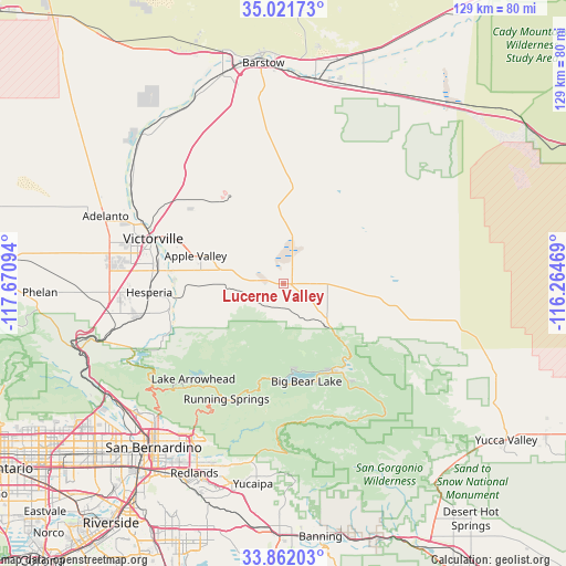
Lucerne Valley GPS coordinates[2]
34° 26' 38.004" North, 116° 58' 4.116" West
| Map corner | latitude | longitude |
|---|---|---|
| Upper-left | 35.02173°, | -117.67094° |
| Center: | 34.44389°, | -116.96781° |
| Lower-right: | 33.86203°, | -116.26469° |
| Map W x H: | 128.9×128.9 km | = 80.1×80.1mi |
| max Lat: | 71.29058° ⇑77.9% North |
| Lucerne Valley: | 34.44389° |
| min Lat: | ⇓22.1% South 19.06759° |
| min Long | Lucerne Valley | max Long |
| -171.73463° | -116.96781° | -66.98998° |
| W 10.3%⇐ | ⇒89.7% E |
Elevation
Elevation of Lucerne Valley is 898 m = 2946 ft, and this is 603.2 m = 1979 ft above average elevation for this country.
| Max E: |
3189 m = 10463 ft | 7.3% |
| Lucerne Valley | 898 m 2946 ft | |
| Avg. | 294.8 m = 967 ft | |
Min E: |
-60 m = -197 ft | 92.7% |
See also: United States elevation on elevation.city.
Geographical zone
Lucerne Valley is located in North temperate zone (between Tropic of Cancer and the Arctic Circle). Distance of this Northern Tropic circle is 1223.9 km =760.5 mi to South.| Distance of | km | miles | from Lucerne Valley |
|---|---|---|---|
| North Pole | 6177.3 | 3838.4 | to North |
| Arctic Circle | 3571.4 | 2219.2 | to North |
| Tropic Cancer | 1223.9 | 760.5 | to South |
| Equator | 3829.8 | 2379.7 | to South |


Nearby cities:
15 places around Lucerne Valley: (largest is in red/bold)
• Adelanto
43.3 km =26.9 mi,  290°
290°
• Apple Valley
21 km =13 mi, 287°
• Big Bear City
23.2 km =14.4 mi,  150°
150°
• Big Bear Lake
22.8 km =14.2 mi,  166°
166°
• Crestline
36.8 km =22.9 mi,  232°
232°
• Hesperia
30.6 km =19 mi,  266°
266°
• Highland
41.5 km =25.8 mi,  212°
212°
• Lake Arrowhead
29.8 km =18.5 mi,  223°
223°
• Mentone
44.3 km =27.5 mi,  200°
200°
• Mountain View Acres
35.4 km =22 mi,  279°
279°
• Oak Glen
43.9 km =27.3 mi,  177°
177°
• Oak Hills
38.5 km =23.9 mi,  259°
259°
• Running Springs
29.3 km =18.2 mi, 206°
• Spring Valley Lake
28.1 km =17.5 mi, 281°
• Victorville
31.4 km =19.5 mi, 289°
Sources, notices
• [Note1] Compared only with cities in United States existing in our database
• [Src1] Map data: © OpenStreetMap contributors (CC-BY-SA)
• [Src2] Other city data from geonames.org with taken over terms of usage.
• [Src3] Geographical zone / Annual Mean Temperature by Robert A. Rohde @ Wikipedia
