Fort Irwin geodata
Fort Irwin (California) is a populated place; located in United States in America/Los_Angeles (GMT-7) time zone. With population of 8,845 people, there are 4862 cities with bigger population in this country. Compared to other cities in United States, 73.9% of cities are located further ↑North; 89.4% of cities are located further →East and 91.6% of cities have lower elevation than Fort Irwin. Note1


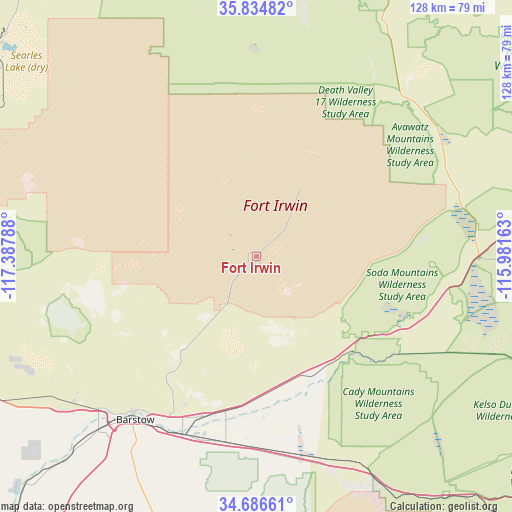
Fort Irwin GPS coordinates[2]
35° 15' 45.9" North, 116° 41' 5.1" West
| Map corner | latitude | longitude |
|---|---|---|
| Upper-left | 35.83482°, | -117.38788° |
| Center: | 35.26275°, | -116.68475° |
| Lower-right: | 34.68661°, | -115.98163° |
| Map W x H: | 127.7×127.7 km | = 79.3×79.3mi |
| max Lat: | 71.29058° ⇑73.9% North |
| Fort Irwin: | 35.26275° |
| min Lat: | ⇓26.1% South 19.06759° |
| min Long | Fort Irwin | max Long |
| -171.73463° | -116.68475° | -66.98998° |
| W 10.6%⇐ | ⇒89.4% E |
Elevation
Elevation of Fort Irwin is 762 m = 2500 ft, and this is 467.2 m = 1533 ft above average elevation for this country.
| Max E: |
3189 m = 10463 ft | 8.4% |
| Fort Irwin | 762 m 2500 ft | |
| Avg. | 294.8 m = 967 ft | |
Min E: |
-60 m = -197 ft | 91.6% |
See also: United States elevation on elevation.city.
Geographical zone
Fort Irwin is located in North temperate zone (between Tropic of Cancer and the Arctic Circle). Distance of this Northern Tropic circle is 1314.9 km =817 mi to South.| Distance of | km | miles | from Fort Irwin |
|---|---|---|---|
| North Pole | 6086.2 | 3781.8 | to North |
| Arctic Circle | 3480.3 | 2162.6 | to North |
| Tropic Cancer | 1314.9 | 817 | to South |
| Equator | 3920.9 | 2436.3 | to South |


Nearby cities:
15 places around Fort Irwin: (largest is in red/bold)
• Adelanto
100.4 km =62.4 mi,  221°
221°
• Apple Valley
96.3 km =59.8 mi,  208°
208°
• Baker
55.4 km =34.4 mi,  89°
89°
• Barstow
50.9 km =31.6 mi, 217°
• Barstow Heights
55.2 km =34.3 mi, 217°
• Boron
92.5 km =57.5 mi,  251°
251°
• China Lake Acres
106.4 km =66.1 mi,  293°
293°
• Lenwood
57.4 km =35.7 mi, 221°
• Lucerne Valley
94.6 km =58.8 mi,  195°
195°
• Mountain View Acres
104.5 km =64.9 mi, 215°
• Ridgecrest
97.9 km =60.8 mi, 294°
• Searles Valley
85.9 km =53.4 mi,  310°
310°
• Silver Lakes
82.9 km =51.5 mi,  226°
226°
• Spring Valley Lake
100.7 km =62.6 mi, 211°
• Victorville
97.9 km =60.8 mi, 214°
Sources, notices
• [Note1] Compared only with cities in United States existing in our database
• [Src1] Map data: © OpenStreetMap contributors (CC-BY-SA)
• [Src2] Other city data from geonames.org with taken over terms of usage.
• [Src3] Geographical zone / Annual Mean Temperature by Robert A. Rohde @ Wikipedia
