Chino geodata
Chino (California) is a populated place; located in United States in America/Los_Angeles (GMT-7) time zone. With population of 85,595 people, there are 450 cities with bigger population in this country. Compared to other cities in United States, 80.1% of cities are located further ↑North; 90.5% of cities are located further →East and 55.8% of cities have lower elevation than Chino. Note1


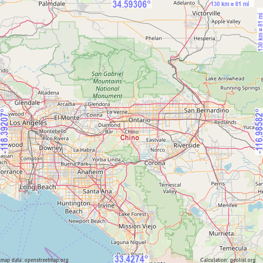
Chino GPS coordinates[2]
34° 0' 44.028" North, 117° 41' 20.184" West
| Map corner | latitude | longitude |
|---|---|---|
| Upper-left | 34.59306°, | -118.39207° |
| Center: | 34.01223°, | -117.68894° |
| Lower-right: | 33.4274°, | -116.98582° |
| Map W x H: | 129.6×129.6 km | = 80.5×80.5mi |
| max Lat: | 71.29058° ⇑80.1% North |
| Chino: | 34.01223° |
| min Lat: | ⇓19.9% South 19.06759° |
| min Long | Chino | max Long |
| -171.73463° | -117.68894° | -66.98998° |
| W 9.5%⇐ | ⇒90.5% E |
Elevation
Elevation of Chino is 222 m = 728 ft, and this is 72.8 m = 239 ft below average elevation for this country.
| Max E: |
3189 m = 10463 ft | 44.2% |
| Avg. | 294.8 m = 967 ft | |
| Chino | 222 m = 728 ft | |
Min E: |
-60 m = -197 ft | 55.8% |
See also: Chino elevation on elevation.city.
Geographical zone
Chino is located in North temperate zone (between Tropic of Cancer and the Arctic Circle). Distance of this Northern Tropic circle is 1175.9 km =730.7 mi to South.| Distance of | km | miles | from Chino |
|---|---|---|---|
| North Pole | 6225.3 | 3868.2 | to North |
| Arctic Circle | 3619.4 | 2249 | to North |
| Tropic Cancer | 1175.9 | 730.7 | to South |
| Equator | 3781.8 | 2349.9 | to South |


Nearby cities:
15 places around Chino: (largest is in red/bold)
• Chino Hills
6.8 km =4.2 mi,  252°
252°
• Claremont
9.8 km =6.1 mi,  343°
343°
• Diamond Bar
11.3 km =7 mi,  279°
279°
• Eastvale
12.7 km =7.9 mi,  115°
115°
• Jurupa Valley
16.1 km =10 mi,  97°
97°
• La Verne
12.2 km =7.6 mi,  323°
323°
• Los Serranos
4.7 km =2.9 mi,  201°
201°
• Montclair
7.3 km =4.5 mi,  359°
359°
• Norco
15.8 km =9.8 mi, 124°
• Ontario
6.7 km =4.2 mi,  31°
31°
• Pomona
7.5 km =4.7 mi,  309°
309°
• Rancho Cucamonga
13.7 km =8.5 mi,  40°
40°
• San Antonio Heights
16.2 km =10.1 mi,  10°
10°
• San Dimas
15.1 km =9.4 mi, 314°
• Upland
10.2 km =6.3 mi,  21°
21°
Sources, notices
• [Note1] Compared only with cities in United States existing in our database
• [Src1] Map data: © OpenStreetMap contributors (CC-BY-SA)
• [Src2] Other city data from geonames.org with taken over terms of usage.
• [Src3] Geographical zone / Annual Mean Temperature by Robert A. Rohde @ Wikipedia
