Los Serranos geodata
Los Serranos (California) is a populated place; located in United States in America/Los_Angeles (GMT-7) time zone. With population of 7,099 people, there are 5764 cities with bigger population in this country. Compared to other cities in United States, 80.4% of cities are located further ↑North; 90.5% of cities are located further →East and 51.9% of cities have lower elevation than Los Serranos. Note1


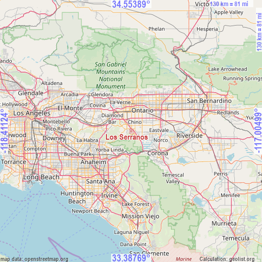
Los Serranos GPS coordinates[2]
33° 58' 22.044" North, 117° 42' 29.196" West
| Map corner | latitude | longitude |
|---|---|---|
| Upper-left | 34.55389°, | -118.41124° |
| Center: | 33.97279°, | -117.70811° |
| Lower-right: | 33.38769°, | -117.00499° |
| Map W x H: | 129.7×129.7 km | = 80.6×80.6mi |
| max Lat: | 71.29058° ⇑80.4% North |
| Los Serranos: | 33.97279° |
| min Lat: | ⇓19.6% South 19.06759° |
| min Long | Los Serranos | max Long |
| -171.73463° | -117.70811° | -66.98998° |
| W 9.5%⇐ | ⇒90.5% E |
Elevation
Elevation of Los Serranos is 206 m = 676 ft, and this is 88.8 m = 291 ft below average elevation for this country.
| Max E: |
3189 m = 10463 ft | 48.1% |
| Avg. | 294.8 m = 967 ft | |
| Los Serranos | 206 m = 676 ft | |
Min E: |
-60 m = -197 ft | 51.9% |
See also: United States elevation on elevation.city.
Geographical zone
Los Serranos is located in North temperate zone (between Tropic of Cancer and the Arctic Circle). Distance of this Northern Tropic circle is 1171.5 km =727.9 mi to South.| Distance of | km | miles | from Los Serranos |
|---|---|---|---|
| North Pole | 6229.6 | 3870.9 | to North |
| Arctic Circle | 3623.8 | 2251.7 | to North |
| Tropic Cancer | 1171.5 | 727.9 | to South |
| Equator | 3777.4 | 2347.2 | to South |


Nearby cities:
15 places around Los Serranos: (largest is in red/bold)
• Chino
4.7 km =2.9 mi,  21°
21°
• Chino Hills
5.2 km =3.2 mi,  296°
296°
• Claremont
13.8 km =8.6 mi,  355°
355°
• Corona
17 km =10.6 mi,  129°
129°
• Diamond Bar
11.3 km =7 mi, 303°
• Eastvale
13.3 km =8.3 mi,  94°
94°
• La Verne
15.3 km =9.5 mi,  338°
338°
• Montclair
11.8 km =7.3 mi,  8°
8°
• Norco
15.4 km =9.6 mi,  107°
107°
• Ontario
11.4 km =7.1 mi,  27°
27°
• Pomona
10 km =6.2 mi, 336°
• San Dimas
17.4 km =10.8 mi,  328°
328°
• Upland
14.9 km =9.3 mi, 21°
• Walnut
15.4 km =9.6 mi,  290°
290°
• Yorba Linda
13.5 km =8.4 mi,  225°
225°
Sources, notices
• [Note1] Compared only with cities in United States existing in our database
• [Src1] Map data: © OpenStreetMap contributors (CC-BY-SA)
• [Src2] Other city data from geonames.org with taken over terms of usage.
• [Src3] Geographical zone / Annual Mean Temperature by Robert A. Rohde @ Wikipedia
