Pomona geodata
Pomona (California) is a populated place; located in United States in America/Los_Angeles (GMT-7) time zone. With population of 153,266 people, there are 187 cities with bigger population in this country. Compared to other cities in United States, 79.9% of cities are located further ↑North; 90.6% of cities are located further →East and 65.4% of cities have lower elevation than Pomona. Note1


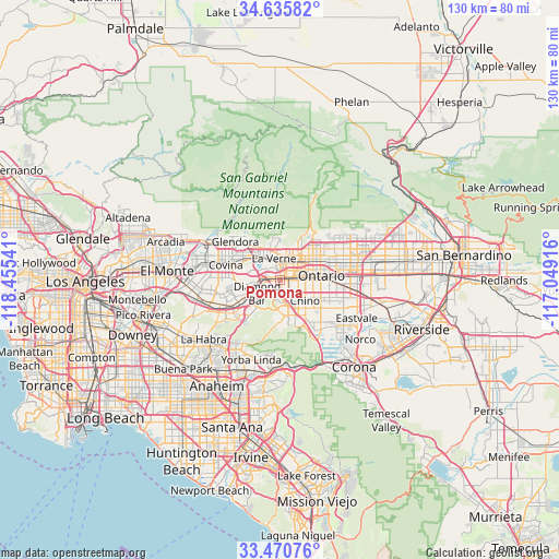
Pomona GPS coordinates[2]
34° 3' 19.044" North, 117° 45' 8.208" West
| Map corner | latitude | longitude |
|---|---|---|
| Upper-left | 34.63582°, | -118.45541° |
| Center: | 34.05529°, | -117.75228° |
| Lower-right: | 33.47076°, | -117.04916° |
| Map W x H: | 129.5×129.5 km | = 80.5×80.5mi |
| max Lat: | 71.29058° ⇑79.9% North |
| Pomona: | 34.05529° |
| min Lat: | ⇓20.1% South 19.06759° |
| min Long | Pomona | max Long |
| -171.73463° | -117.75228° | -66.98998° |
| W 9.4%⇐ | ⇒90.6% E |
Elevation
Elevation of Pomona is 264 m = 866 ft, and this is 30.8 m = 101 ft below average elevation for this country.
| Max E: |
3189 m = 10463 ft | 34.6% |
| Avg. | 294.8 m = 967 ft | |
| Pomona | 264 m = 866 ft | |
Min E: |
-60 m = -197 ft | 65.4% |
See also: Pomona elevation on elevation.city.
Geographical zone
Pomona is located in North temperate zone (between Tropic of Cancer and the Arctic Circle). Distance of this Northern Tropic circle is 1180.7 km =733.7 mi to South.| Distance of | km | miles | from Pomona |
|---|---|---|---|
| North Pole | 6220.5 | 3865.2 | to North |
| Arctic Circle | 3614.6 | 2246 | to North |
| Tropic Cancer | 1180.7 | 733.7 | to South |
| Equator | 3786.6 | 2352.9 | to South |


Nearby cities:
15 places around Pomona: (largest is in red/bold)
• Charter Oak
10.1 km =6.3 mi,  301°
301°
• Chino
7.5 km =4.7 mi,  129°
129°
• Chino Hills
6.9 km =4.3 mi,  185°
185°
• Claremont
5.5 km =3.4 mi,  33°
33°
• Covina
13.3 km =8.3 mi,  286°
286°
• Diamond Bar
6.1 km =3.8 mi,  240°
240°
• Glendora
13.8 km =8.6 mi,  310°
310°
• La Verne
5.3 km =3.3 mi,  344°
344°
• Los Serranos
10 km =6.2 mi,  156°
156°
• Montclair
6.3 km =3.9 mi,  66°
66°
• Ontario
9.4 km =5.8 mi,  84°
84°
• San Antonio Heights
14.2 km =8.8 mi,  38°
38°
• San Dimas
7.6 km =4.7 mi,  318°
318°
• Upland
10.7 km =6.6 mi,  63°
63°
• Walnut
11.1 km =6.9 mi,  249°
249°
Sources, notices
• [Note1] Compared only with cities in United States existing in our database
• [Src1] Map data: © OpenStreetMap contributors (CC-BY-SA)
• [Src2] Other city data from geonames.org with taken over terms of usage.
• [Src3] Geographical zone / Annual Mean Temperature by Robert A. Rohde @ Wikipedia
