Delano geodata
Delano (California) is a populated place; located in United States in America/Los_Angeles (GMT-7) time zone. With population of 52,733 people, there are 883 cities with bigger population in this country. Compared to other cities in United States, 71.5% of cities are located further ↑North; 92.1% of cities are located further →East and 70.1% of cities have higher elevation than Delano. Note1


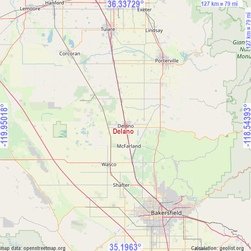
Delano GPS coordinates[2]
35° 46' 7.824" North, 119° 14' 49.38" West
| Map corner | latitude | longitude |
|---|---|---|
| Upper-left | 36.33729°, | -119.95018° |
| Center: | 35.76884°, | -119.24705° |
| Lower-right: | 35.1963°, | -118.54393° |
| Map W x H: | 126.9×126.9 km | = 78.9×78.9mi |
| max Lat: | 71.29058° ⇑71.5% North |
| Delano: | 35.76884° |
| min Lat: | ⇓28.5% South 19.06759° |
| min Long | Delano | max Long |
| -171.73463° | -119.24705° | -66.98998° |
| W 7.9%⇐ | ⇒92.1% E |
Elevation
Elevation of Delano is 100 m = 328 ft, and this is 194.8 m = 639 ft below average elevation for this country.
| Max E: |
3189 m = 10463 ft | 70.1% |
| Avg. | 294.8 m = 967 ft | |
| Delano | 100 m = 328 ft | |
Min E: |
-60 m = -197 ft | 29.9% |
See also: Delano elevation on elevation.city.
Geographical zone
Delano is located in North temperate zone (between Tropic of Cancer and the Arctic Circle). Distance of this Northern Tropic circle is 1371.2 km =852 mi to South.| Distance of | km | miles | from Delano |
|---|---|---|---|
| North Pole | 6029.9 | 3746.8 | to North |
| Arctic Circle | 3424.1 | 2127.6 | to North |
| Tropic Cancer | 1371.2 | 852 | to South |
| Equator | 3977.1 | 2471.3 | to South |


Nearby cities:
15 places around Delano: (largest is in red/bold)
• Alpaugh
25.4 km =15.8 mi,  301°
301°
• Ducor
22.6 km =14 mi,  52°
52°
• Earlimart
13 km =8.1 mi,  349°
349°
• McFarland
10.2 km =6.3 mi,  170°
170°
• Pixley
22.6 km =14 mi, 349°
• Poplar-Cotton Center
33.2 km =20.6 mi,  15°
15°
• Porterville
38.9 km =24.2 mi,  32°
32°
• Richgrove
12.9 km =8 mi,  76°
76°
• Shafter
29.9 km =18.6 mi,  184°
184°
• Smith Corner
32.4 km =20.1 mi,  185°
185°
• Terra Bella
28.2 km =17.5 mi,  40°
40°
• Teviston
18 km =11.2 mi, 351°
• Tipton
32.8 km =20.4 mi, 349°
• Wasco
21.2 km =13.2 mi,  203°
203°
• Woodville
36.4 km =22.6 mi,  6°
6°
Sources, notices
• [Note1] Compared only with cities in United States existing in our database
• [Src1] Map data: © OpenStreetMap contributors (CC-BY-SA)
• [Src2] Other city data from geonames.org with taken over terms of usage.
• [Src3] Geographical zone / Annual Mean Temperature by Robert A. Rohde @ Wikipedia
