Wasco geodata
Wasco (California) is a populated place; located in United States in America/Los_Angeles (GMT-7) time zone. With population of 26,279 people, there are 1908 cities with bigger population in this country. Compared to other cities in United States, 72.2% of cities are located further ↑North; 92.3% of cities are located further →East and 70% of cities have higher elevation than Wasco. Note1


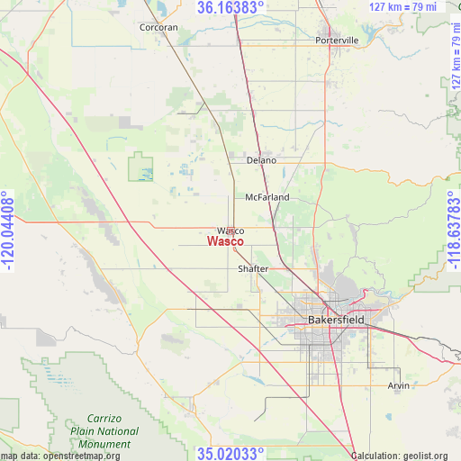
Wasco GPS coordinates[2]
35° 35' 38.832" North, 119° 20' 27.42" West
| Map corner | latitude | longitude |
|---|---|---|
| Upper-left | 36.16383°, | -120.04408° |
| Center: | 35.59412°, | -119.34095° |
| Lower-right: | 35.02033°, | -118.63783° |
| Map W x H: | 127.1×127.1 km | = 79×79mi |
| max Lat: | 71.29058° ⇑72.2% North |
| Wasco: | 35.59412° |
| min Lat: | ⇓27.8% South 19.06759° |
| min Long | Wasco | max Long |
| -171.73463° | -119.34095° | -66.98998° |
| W 7.7%⇐ | ⇒92.3% E |
Elevation
Elevation of Wasco is 101 m = 331 ft, and this is 193.8 m = 636 ft below average elevation for this country.
| Max E: |
3189 m = 10463 ft | 70% |
| Avg. | 294.8 m = 967 ft | |
| Wasco | 101 m = 331 ft | |
Min E: |
-60 m = -197 ft | 30% |
See also: United States elevation on elevation.city.
Geographical zone
Wasco is located in North temperate zone (between Tropic of Cancer and the Arctic Circle). Distance of this Northern Tropic circle is 1351.8 km =840 mi to South.| Distance of | km | miles | from Wasco |
|---|---|---|---|
| North Pole | 6049.4 | 3758.9 | to North |
| Arctic Circle | 3443.5 | 2139.7 | to North |
| Tropic Cancer | 1351.8 | 840 | to South |
| Equator | 3957.7 | 2459.2 | to South |


Nearby cities:
15 places around Wasco: (largest is in red/bold)
• Alpaugh
35.2 km =21.9 mi,  337°
337°
• Bakersfield
38.1 km =23.7 mi,  130°
130°
• Buttonwillow
24.5 km =15.2 mi,  208°
208°
• Delano
21.2 km =13.2 mi,  23°
23°
• Earlimart
32.8 km =20.4 mi,  10°
10°
• Greenacres
31.4 km =19.5 mi,  138°
138°
• Lost Hills
32 km =19.9 mi,  274°
274°
• McFarland
13.7 km =8.5 mi,  47°
47°
• Oildale
35 km =21.7 mi,  123°
123°
• Pixley
41.9 km =26 mi, 6°
• Richgrove
30.8 km =19.1 mi,  43°
43°
• Rosedale
29.4 km =18.3 mi, 142°
• Shafter
12.1 km =7.5 mi,  148°
148°
• Smith Corner
14.1 km =8.8 mi,  156°
156°
• Teviston
37.7 km =23.4 mi, 8°
Sources, notices
• [Note1] Compared only with cities in United States existing in our database
• [Src1] Map data: © OpenStreetMap contributors (CC-BY-SA)
• [Src2] Other city data from geonames.org with taken over terms of usage.
• [Src3] Geographical zone / Annual Mean Temperature by Robert A. Rohde @ Wikipedia
