McFarland geodata
McFarland (California) is a populated place; located in United States in America/Los_Angeles (GMT-7) time zone. With population of 13,985 people, there are 3440 cities with bigger population in this country. Compared to other cities in United States, 71.9% of cities are located further ↑North; 92.1% of cities are located further →East and 68.5% of cities have higher elevation than McFarland. Note1


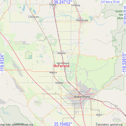
McFarland GPS coordinates[2]
35° 40' 40.836" North, 119° 13' 45.372" West
| Map corner | latitude | longitude |
|---|---|---|
| Upper-left | 36.24712°, | -119.9324° |
| Center: | 35.67801°, | -119.22927° |
| Lower-right: | 35.10482°, | -118.52615° |
| Map W x H: | 127×127 km | = 78.9×78.9mi |
| max Lat: | 71.29058° ⇑71.9% North |
| McFarland: | 35.67801° |
| min Lat: | ⇓28.1% South 19.06759° |
| min Long | McFarland | max Long |
| -171.73463° | -119.22927° | -66.98998° |
| W 7.9%⇐ | ⇒92.1% E |
Elevation
Elevation of McFarland is 110 m = 361 ft, and this is 184.8 m = 606 ft below average elevation for this country.
| Max E: |
3189 m = 10463 ft | 68.5% |
| Avg. | 294.8 m = 967 ft | |
| McFarland | 110 m = 361 ft | |
Min E: |
-60 m = -197 ft | 31.5% |
See also: United States elevation on elevation.city.
Geographical zone
McFarland is located in North temperate zone (between Tropic of Cancer and the Arctic Circle). Distance of this Northern Tropic circle is 1361.1 km =845.7 mi to South.| Distance of | km | miles | from McFarland |
|---|---|---|---|
| North Pole | 6040 | 3753.1 | to North |
| Arctic Circle | 3434.2 | 2133.9 | to North |
| Tropic Cancer | 1361.1 | 845.7 | to South |
| Equator | 3967 | 2465 | to South |


Nearby cities:
15 places around McFarland: (largest is in red/bold)
• Alpaugh
32.9 km =20.4 mi,  315°
315°
• Buttonwillow
37.7 km =23.4 mi,  215°
215°
• Delano
10.2 km =6.3 mi,  350°
350°
• Ducor
28.9 km =18 mi,  34°
34°
• Earlimart
23.2 km =14.4 mi, 350°
• Greenacres
34.5 km =21.4 mi,  161°
161°
• Oildale
34.4 km =21.4 mi,  146°
146°
• Pixley
32.8 km =20.4 mi, 350°
• Richgrove
17.1 km =10.6 mi,  39°
39°
• Rosedale
33.6 km =20.9 mi,  166°
166°
• Shafter
20.1 km =12.5 mi,  191°
191°
• Smith Corner
22.7 km =14.1 mi, 191°
• Terra Bella
35.8 km =22.2 mi, 27°
• Teviston
28.2 km =17.5 mi, 350°
• Wasco
13.7 km =8.5 mi,  227°
227°
Sources, notices
• [Note1] Compared only with cities in United States existing in our database
• [Src1] Map data: © OpenStreetMap contributors (CC-BY-SA)
• [Src2] Other city data from geonames.org with taken over terms of usage.
• [Src3] Geographical zone / Annual Mean Temperature by Robert A. Rohde @ Wikipedia
