Delleker geodata
Delleker (California) is a populated place; located in United States in America/Los_Angeles (GMT-7) time zone. With population of 705 people, there are 18626 cities with bigger population in this country. Compared to other cities in United States, 51.6% of cities are located further ↓South; 93.3% of cities are located further →East and 96.6% of cities have lower elevation than Delleker. Note1


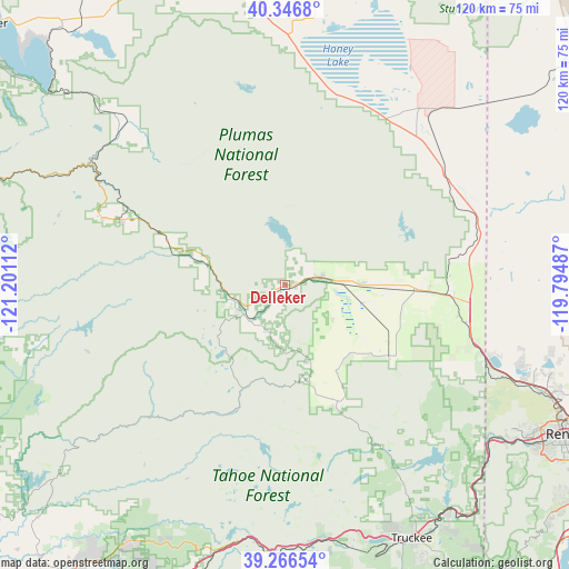
Delleker GPS coordinates[2]
39° 48' 31.644" North, 120° 29' 52.764" West
| Map corner | latitude | longitude |
|---|---|---|
| Upper-left | 40.3468°, | -121.20112° |
| Center: | 39.80879°, | -120.49799° |
| Lower-right: | 39.26654°, | -119.79487° |
| Map W x H: | 120.1×120.1 km | = 74.6×74.6mi |
| max Lat: | 71.29058° ⇑48.4% North |
| Delleker: | 39.80879° |
| min Lat: | ⇓51.6% South 19.06759° |
| min Long | Delleker | max Long |
| -171.73463° | -120.49799° | -66.98998° |
| W 6.7%⇐ | ⇒93.3% E |
Elevation
Elevation of Delleker is 1491 m = 4892 ft, and this is 1196.2 m = 3925 ft above average elevation for this country.
| Max E: |
3189 m = 10463 ft | 3.4% |
| Delleker | 1491 m 4892 ft | |
| Avg. | 294.8 m = 967 ft | |
Min E: |
-60 m = -197 ft | 96.6% |
See also: United States elevation on elevation.city.
Geographical zone
Delleker is located in North temperate zone (between Tropic of Cancer and the Arctic Circle). Distance of this Northern Tropic circle is 1820.4 km =1131.1 mi to South.| Distance of | km | miles | from Delleker |
|---|---|---|---|
| North Pole | 5580.7 | 3467.7 | to North |
| Arctic Circle | 2974.9 | 1848.5 | to North |
| Tropic Cancer | 1820.4 | 1131.1 | to South |
| Equator | 4426.3 | 2750.4 | to South |


Nearby cities:
15 places around Delleker: (largest is in red/bold)
• Cold Springs
46.8 km =29.1 mi,  107°
107°
• Downieville
39.5 km =24.5 mi,  225°
225°
• Doyle
41.5 km =25.8 mi,  54°
54°
• East Quincy
36.9 km =22.9 mi,  292°
292°
• Graeagle
11.3 km =7 mi,  245°
245°
• Greenville
53.3 km =33.1 mi,  313°
313°
• Janesville
54.3 km =33.7 mi,  357°
357°
• Lemmon Valley
59.2 km =36.8 mi, 108°
• Loyalton
26.5 km =16.5 mi,  123°
123°
• Mogul
58.9 km =36.6 mi, 123°
• Patton Village
47.1 km =29.3 mi,  38°
38°
• Portola
2.5 km =1.6 mi,  85°
85°
• Quincy
40.8 km =25.4 mi, 290°
• Truckee
59.9 km =37.2 mi,  153°
153°
• Verdi
54.3 km =33.7 mi,  126°
126°
Sources, notices
• [Note1] Compared only with cities in United States existing in our database
• [Src1] Map data: © OpenStreetMap contributors (CC-BY-SA)
• [Src2] Other city data from geonames.org with taken over terms of usage.
• [Src3] Geographical zone / Annual Mean Temperature by Robert A. Rohde @ Wikipedia
