Doyle geodata
Doyle (California) is a populated place; located in United States in America/Los_Angeles (GMT-7) time zone. With population of 678 people, there are 18889 cities with bigger population in this country. Compared to other cities in United States, 53.9% of cities are located further ↓South; 92.9% of cities are located further →East and 95.2% of cities have lower elevation than Doyle. Note1


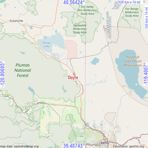
Doyle GPS coordinates[2]
40° 1' 40.656" North, 120° 6' 13.752" West
| Map corner | latitude | longitude |
|---|---|---|
| Upper-left | 40.56424°, | -120.80695° |
| Center: | 40.02796°, | -120.10382° |
| Lower-right: | 39.48743°, | -119.4007° |
| Map W x H: | 119.7×119.7 km | = 74.4×74.4mi |
| max Lat: | 71.29058° ⇑46.1% North |
| Doyle: | 40.02796° |
| min Lat: | ⇓53.9% South 19.06759° |
| min Long | Doyle | max Long |
| -171.73463° | -120.10382° | -66.98998° |
| W 7.1%⇐ | ⇒92.9% E |
Elevation
Elevation of Doyle is 1305 m = 4281 ft, and this is 1010.2 m = 3314 ft above average elevation for this country.
| Max E: |
3189 m = 10463 ft | 4.8% |
| Doyle | 1305 m 4281 ft | |
| Avg. | 294.8 m = 967 ft | |
Min E: |
-60 m = -197 ft | 95.2% |
See also: United States elevation on elevation.city.
Geographical zone
Doyle is located in North temperate zone (between Tropic of Cancer and the Arctic Circle). Distance of this Northern Tropic circle is 1844.8 km =1146.3 mi to South.| Distance of | km | miles | from Doyle |
|---|---|---|---|
| North Pole | 5556.4 | 3452.6 | to North |
| Arctic Circle | 2950.5 | 1833.4 | to North |
| Tropic Cancer | 1844.8 | 1146.3 | to South |
| Equator | 4450.7 | 2765.5 | to South |


Nearby cities:
15 places around Doyle: (largest is in red/bold)
• Cold Springs
40.2 km =25 mi,  164°
164°
• Delleker
41.5 km =25.8 mi,  234°
234°
• Golden Valley
51.6 km =32.1 mi,  152°
152°
• Graeagle
52.7 km =32.7 mi,  236°
236°
• Janesville
46.6 km =29 mi,  309°
309°
• Johnstonville
57.1 km =35.5 mi, 313°
• Lemmon Valley
48.9 km =30.4 mi, 152°
• Loyalton
40.8 km =25.4 mi,  196°
196°
• Mogul
59.2 km =36.8 mi,  165°
165°
• Patton Village
13.3 km =8.3 mi,  340°
340°
• Portola
39.4 km =24.5 mi, 232°
• Reno
60.7 km =37.7 mi, 155°
• Spanish Springs
54 km =33.6 mi,  141°
141°
• Sun Valley
55.6 km =34.5 mi, 149°
• Verdi
57.5 km =35.7 mi, 170°
Sources, notices
• [Note1] Compared only with cities in United States existing in our database
• [Src1] Map data: © OpenStreetMap contributors (CC-BY-SA)
• [Src2] Other city data from geonames.org with taken over terms of usage.
• [Src3] Geographical zone / Annual Mean Temperature by Robert A. Rohde @ Wikipedia
