Fairfield geodata
Fairfield (California) is a seat of a second-order administrative division; located in United States in America/Los_Angeles (GMT-7) time zone. With population of 112,970 people, there are 288 cities with bigger population in this country. Compared to other cities in United States, 60.3% of cities are located further ↑North; 95.2% of cities are located further →East and 98.8% of cities have higher elevation than Fairfield. Note1


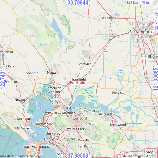
Fairfield GPS coordinates[2]
38° 14' 57.696" North, 122° 2' 23.892" West
| Map corner | latitude | longitude |
|---|---|---|
| Upper-left | 38.79944°, | -122.7431° |
| Center: | 38.24936°, | -122.03997° |
| Lower-right: | 37.69508°, | -121.33685° |
| Map W x H: | 122.8×122.8 km | = 76.3×76.3mi |
| max Lat: | 71.29058° ⇑60.3% North |
| Fairfield: | 38.24936° |
| min Lat: | ⇓39.7% South 19.06759° |
| min Long | Fairfield | max Long |
| -171.73463° | -122.03997° | -66.98998° |
| W 4.8%⇐ | ⇒95.2% E |
Elevation
Elevation of Fairfield is 4 m = 13 ft, and this is 290.8 m = 954 ft below average elevation for this country.
| Max E: |
3189 m = 10463 ft | 98.8% |
| Avg. | 294.8 m = 967 ft | |
| Fairfield | 4 m = 13 ft | |
Min E: |
-60 m = -197 ft | 1.2% |
See also: Fairfield elevation on elevation.city.
Geographical zone
Fairfield is located in North temperate zone (between Tropic of Cancer and the Arctic Circle). Distance of this Northern Tropic circle is 1647 km =1023.4 mi to South.| Distance of | km | miles | from Fairfield |
|---|---|---|---|
| North Pole | 5754.1 | 3575.4 | to North |
| Arctic Circle | 3148.2 | 1956.2 | to North |
| Tropic Cancer | 1647 | 1023.4 | to South |
| Equator | 4252.9 | 2642.6 | to South |


Nearby cities:
15 places around Fairfield: (largest is in red/bold)
• Allendale
23.3 km =14.5 mi,  21°
21°
• American Canyon
21 km =13 mi,  246°
246°
• Bay Point
25.4 km =15.8 mi,  164°
164°
• Benicia
24.5 km =15.2 mi,  205°
205°
• Clyde
24.9 km =15.5 mi,  177°
177°
• Crockett
26.6 km =16.5 mi, 214°
• Green Valley
10.7 km =6.6 mi,  272°
272°
• Hartley
20.3 km =12.6 mi, 23°
• Martinez
26.9 km =16.7 mi,  197°
197°
• Mountain View
27.6 km =17.1 mi,  194°
194°
• Napa
22.1 km =13.7 mi,  283°
283°
• Suisun
1.2 km =0.7 mi, 181°
• Vacaville
12.8 km =8 mi, 20°
• Vallejo
24.9 km =15.5 mi,  229°
229°
• Vine Hill
27.2 km =16.9 mi, 190°
Sources, notices
• [Note1] Compared only with cities in United States existing in our database
• [Src1] Map data: © OpenStreetMap contributors (CC-BY-SA)
• [Src2] Other city data from geonames.org with taken over terms of usage.
• [Src3] Geographical zone / Annual Mean Temperature by Robert A. Rohde @ Wikipedia
