Hollister geodata
Hollister (California) is a seat of a second-order administrative division; located in United States in America/Los_Angeles (GMT-7) time zone. With population of 37,462 people, there are 1301 cities with bigger population in this country. Compared to other cities in United States, 66.7% of cities are located further ↑North; 94.2% of cities are located further →East and 72.7% of cities have higher elevation than Hollister. Note1


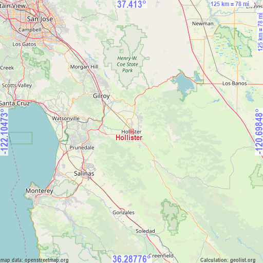
Hollister GPS coordinates[2]
36° 51' 8.82" North, 121° 24' 5.76" West
| Map corner | latitude | longitude |
|---|---|---|
| Upper-left | 37.413°, | -122.10473° |
| Center: | 36.85245°, | -121.4016° |
| Lower-right: | 36.28776°, | -120.69848° |
| Map W x H: | 125.1×125.1 km | = 77.7×77.7mi |
| max Lat: | 71.29058° ⇑66.7% North |
| Hollister: | 36.85245° |
| min Lat: | ⇓33.3% South 19.06759° |
| min Long | Hollister | max Long |
| -171.73463° | -121.4016° | -66.98998° |
| W 5.8%⇐ | ⇒94.2% E |
Elevation
Elevation of Hollister is 85 m = 279 ft, and this is 209.8 m = 688 ft below average elevation for this country.
| Max E: |
3189 m = 10463 ft | 72.7% |
| Avg. | 294.8 m = 967 ft | |
| Hollister | 85 m = 279 ft | |
Min E: |
-60 m = -197 ft | 27.3% |
See also: United States elevation on elevation.city.
Geographical zone
Hollister is located in North temperate zone (between Tropic of Cancer and the Arctic Circle). Distance of this Northern Tropic circle is 1491.7 km =926.9 mi to South.| Distance of | km | miles | from Hollister |
|---|---|---|---|
| North Pole | 5909.5 | 3672 | to North |
| Arctic Circle | 3303.6 | 2052.8 | to North |
| Tropic Cancer | 1491.7 | 926.9 | to South |
| Equator | 4097.6 | 2546.1 | to South |


Nearby cities:
15 places around Hollister: (largest is in red/bold)
• Aromas
21.8 km =13.5 mi,  280°
280°
• Boronda
29.7 km =18.5 mi,  234°
234°
• Castroville
33.2 km =20.6 mi,  253°
253°
• Chualar
33 km =20.5 mi,  198°
198°
• Elkhorn
30.3 km =18.8 mi,  264°
264°
• Gilroy
22.6 km =14 mi,  319°
319°
• Interlaken
31.5 km =19.6 mi,  290°
290°
• Las Lomas
29.7 km =18.5 mi,  272°
272°
• Pajaro
31.4 km =19.5 mi, 280°
• Prunedale
25.3 km =15.7 mi, 250°
• Ridgemark
5.5 km =3.4 mi,  144°
144°
• Salinas
29.8 km =18.5 mi, 229°
• San Juan Bautista
12.2 km =7.6 mi, 266°
• San Martin
31.8 km =19.8 mi, 324°
• Watsonville
32.2 km =20 mi, 281°
Sources, notices
• [Note1] Compared only with cities in United States existing in our database
• [Src1] Map data: © OpenStreetMap contributors (CC-BY-SA)
• [Src2] Other city data from geonames.org with taken over terms of usage.
• [Src3] Geographical zone / Annual Mean Temperature by Robert A. Rohde @ Wikipedia
