Gilroy geodata
Gilroy (California) is a populated place; located in United States in America/Los_Angeles (GMT-7) time zone. With population of 53,231 people, there are 876 cities with bigger population in this country. Compared to other cities in United States, 66.1% of cities are located further ↑North; 94.4% of cities are located further →East and 77.1% of cities have higher elevation than Gilroy. Note1


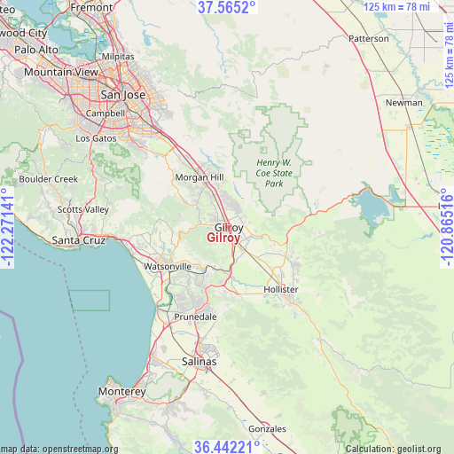
Gilroy GPS coordinates[2]
37° 0' 20.808" North, 121° 34' 5.808" West
| Map corner | latitude | longitude |
|---|---|---|
| Upper-left | 37.5652°, | -122.27141° |
| Center: | 37.00578°, | -121.56828° |
| Lower-right: | 36.44221°, | -120.86516° |
| Map W x H: | 124.9×124.9 km | = 77.6×77.6mi |
| max Lat: | 71.29058° ⇑66.1% North |
| Gilroy: | 37.00578° |
| min Lat: | ⇓33.9% South 19.06759° |
| min Long | Gilroy | max Long |
| -171.73463° | -121.56828° | -66.98998° |
| W 5.6%⇐ | ⇒94.4% E |
Elevation
Elevation of Gilroy is 60 m = 197 ft, and this is 234.8 m = 770 ft below average elevation for this country.
| Max E: |
3189 m = 10463 ft | 77.1% |
| Avg. | 294.8 m = 967 ft | |
| Gilroy | 60 m = 197 ft | |
Min E: |
-60 m = -197 ft | 22.9% |
See also: Gilroy elevation on elevation.city.
Geographical zone
Gilroy is located in North temperate zone (between Tropic of Cancer and the Arctic Circle). Distance of this Northern Tropic circle is 1508.7 km =937.5 mi to South.| Distance of | km | miles | from Gilroy |
|---|---|---|---|
| North Pole | 5892.4 | 3661.4 | to North |
| Arctic Circle | 3286.5 | 2042.1 | to North |
| Tropic Cancer | 1508.7 | 937.5 | to South |
| Equator | 4114.7 | 2556.8 | to South |


Nearby cities:
15 places around Gilroy: (largest is in red/bold)
• Amesti
19.3 km =12 mi,  255°
255°
• Aptos Hills-Larkin Valley
24.1 km =15 mi, 257°
• Aromas
14.6 km =9.1 mi,  206°
206°
• Corralitos
21.2 km =13.2 mi, 264°
• Day Valley
26.3 km =16.3 mi,  277°
277°
• Elkhorn
25.3 km =15.7 mi,  217°
217°
• Freedom
19.8 km =12.3 mi,  246°
246°
• Hollister
22.6 km =14 mi,  139°
139°
• Interlaken
15.9 km =9.9 mi, 247°
• Las Lomas
21.5 km =13.4 mi, 223°
• Morgan Hill
15.8 km =9.8 mi,  331°
331°
• Pajaro
19.6 km =12.2 mi,  234°
234°
• San Juan Bautista
18 km =11.2 mi,  171°
171°
• San Martin
9.6 km =6 mi,  337°
337°
• Watsonville
19.8 km =12.3 mi,  237°
237°
Sources, notices
• [Note1] Compared only with cities in United States existing in our database
• [Src1] Map data: © OpenStreetMap contributors (CC-BY-SA)
• [Src2] Other city data from geonames.org with taken over terms of usage.
• [Src3] Geographical zone / Annual Mean Temperature by Robert A. Rohde @ Wikipedia
