Lincoln geodata
Lincoln (California) is a populated place; located in United States in America/Los_Angeles (GMT-7) time zone. With population of 46,474 people, there are 1035 cities with bigger population in this country. Compared to other cities in United States, 55.9% of cities are located further ↑North; 94.1% of cities are located further →East and 79% of cities have higher elevation than Lincoln. Note1


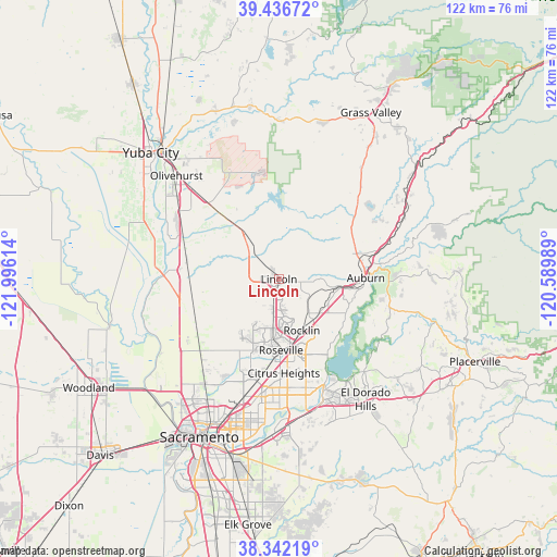
Lincoln GPS coordinates[2]
38° 53' 29.616" North, 121° 17' 34.836" West
| Map corner | latitude | longitude |
|---|---|---|
| Upper-left | 39.43672°, | -121.99614° |
| Center: | 38.89156°, | -121.29301° |
| Lower-right: | 38.34219°, | -120.58989° |
| Map W x H: | 121.7×121.7 km | = 75.6×75.6mi |
| max Lat: | 71.29058° ⇑55.9% North |
| Lincoln: | 38.89156° |
| min Lat: | ⇓44.1% South 19.06759° |
| min Long | Lincoln | max Long |
| -171.73463° | -121.29301° | -66.98998° |
| W 5.9%⇐ | ⇒94.1% E |
Elevation
Elevation of Lincoln is 51 m = 167 ft, and this is 243.8 m = 800 ft below average elevation for this country.
| Max E: |
3189 m = 10463 ft | 79% |
| Avg. | 294.8 m = 967 ft | |
| Lincoln | 51 m = 167 ft | |
Min E: |
-60 m = -197 ft | 21% |
See also: Lincoln elevation on elevation.city.
Geographical zone
Lincoln is located in North temperate zone (between Tropic of Cancer and the Arctic Circle). Distance of this Northern Tropic circle is 1718.4 km =1067.8 mi to South.| Distance of | km | miles | from Lincoln |
|---|---|---|---|
| North Pole | 5682.7 | 3531.1 | to North |
| Arctic Circle | 3076.8 | 1911.8 | to North |
| Tropic Cancer | 1718.4 | 1067.8 | to South |
| Equator | 4324.3 | 2687 | to South |


Nearby cities:
15 places around Lincoln: (largest is in red/bold)
• Antelope
20.6 km =12.8 mi,  188°
188°
• Auburn
18.7 km =11.6 mi,  88°
88°
• Citrus Heights
20.5 km =12.7 mi,  177°
177°
• Cool
24.1 km =15 mi, 91°
• Foothill Farms
24.2 km =15 mi, 192°
• Granite Bay
18.1 km =11.2 mi,  141°
141°
• Loomis
11.7 km =7.3 mi,  132°
132°
• Newcastle
14 km =8.7 mi,  98°
98°
• North Auburn
18.8 km =11.7 mi,  76°
76°
• North Highlands
23.9 km =14.9 mi,  196°
196°
• Penryn
11.6 km =7.2 mi,  112°
112°
• Rocklin
12.3 km =7.6 mi,  156°
156°
• Roseville
15.5 km =9.6 mi, 178°
• Sheridan
12.1 km =7.5 mi,  323°
323°
• Wheatland
17.3 km =10.7 mi, 319°
Sources, notices
• [Note1] Compared only with cities in United States existing in our database
• [Src1] Map data: © OpenStreetMap contributors (CC-BY-SA)
• [Src2] Other city data from geonames.org with taken over terms of usage.
• [Src3] Geographical zone / Annual Mean Temperature by Robert A. Rohde @ Wikipedia
