Morgan Hill geodata
Morgan Hill (California) is a populated place; located in United States in America/Los_Angeles (GMT-7) time zone. With population of 42,948 people, there are 1110 cities with bigger population in this country. Compared to other cities in United States, 65.5% of cities are located further ↑North; 94.5% of cities are located further →East and 68.9% of cities have higher elevation than Morgan Hill. Note1


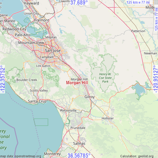
Morgan Hill GPS coordinates[2]
37° 7' 49.8" North, 121° 39' 15.804" West
| Map corner | latitude | longitude |
|---|---|---|
| Upper-left | 37.689°, | -122.35752° |
| Center: | 37.1305°, | -121.65439° |
| Lower-right: | 36.56785°, | -120.95127° |
| Map W x H: | 124.7×124.7 km | = 77.5×77.5mi |
| max Lat: | 71.29058° ⇑65.5% North |
| Morgan Hill: | 37.1305° |
| min Lat: | ⇓34.5% South 19.06759° |
| min Long | Morgan Hill | max Long |
| -171.73463° | -121.65439° | -66.98998° |
| W 5.5%⇐ | ⇒94.5% E |
Elevation
Elevation of Morgan Hill is 107 m = 351 ft, and this is 187.8 m = 616 ft below average elevation for this country.
| Max E: |
3189 m = 10463 ft | 68.9% |
| Avg. | 294.8 m = 967 ft | |
| Morgan Hill | 107 m = 351 ft | |
Min E: |
-60 m = -197 ft | 31.1% |
See also: Morgan Hill elevation on elevation.city.
Geographical zone
Morgan Hill is located in North temperate zone (between Tropic of Cancer and the Arctic Circle). Distance of this Northern Tropic circle is 1522.6 km =946.1 mi to South.| Distance of | km | miles | from Morgan Hill |
|---|---|---|---|
| North Pole | 5878.5 | 3652.7 | to North |
| Arctic Circle | 3272.6 | 2033.5 | to North |
| Tropic Cancer | 1522.6 | 946.1 | to South |
| Equator | 4128.5 | 2565.3 | to South |


Nearby cities:
15 places around Morgan Hill: (largest is in red/bold)
• Amesti
21.6 km =13.4 mi,  210°
210°
• Aptos
27.6 km =17.1 mi,  231°
231°
• Aptos Hills-Larkin Valley
24.7 km =15.3 mi,  220°
220°
• Aromas
26.9 km =16.7 mi,  177°
177°
• Cambrian Park
28.2 km =17.5 mi,  299°
299°
• Corralitos
20.8 km =12.9 mi, 220°
• Day Valley
21.2 km =13.2 mi,  240°
240°
• Freedom
24.1 km =15 mi, 205°
• Gilroy
15.8 km =9.8 mi,  151°
151°
• Interlaken
21.1 km =13.1 mi,  199°
199°
• Pajaro
26.5 km =16.5 mi, 198°
• Rio Del Mar
28.3 km =17.6 mi, 230°
• San Martin
6.4 km =4 mi,  142°
142°
• Seven Trees
23.8 km =14.8 mi,  316°
316°
• Watsonville
26.1 km =16.2 mi, 200°
Sources, notices
• [Note1] Compared only with cities in United States existing in our database
• [Src1] Map data: © OpenStreetMap contributors (CC-BY-SA)
• [Src2] Other city data from geonames.org with taken over terms of usage.
• [Src3] Geographical zone / Annual Mean Temperature by Robert A. Rohde @ Wikipedia
