Fowler geodata
Fowler (California) is a populated place; located in United States in America/Los_Angeles (GMT-7) time zone. With population of 6,266 people, there are 6234 cities with bigger population in this country. Compared to other cities in United States, 67.6% of cities are located further ↑North; 92.5% of cities are located further →East and 70.6% of cities have higher elevation than Fowler. Note1


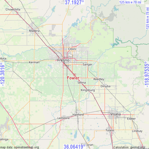
Fowler GPS coordinates[2]
36° 37' 49.836" North, 119° 40' 42.492" West
| Map corner | latitude | longitude |
|---|---|---|
| Upper-left | 37.1927°, | -120.3816° |
| Center: | 36.63051°, | -119.67847° |
| Lower-right: | 36.06419°, | -118.97535° |
| Map W x H: | 125.5×125.5 km | = 78×78mi |
| max Lat: | 71.29058° ⇑67.6% North |
| Fowler: | 36.63051° |
| min Lat: | ⇓32.4% South 19.06759° |
| min Long | Fowler | max Long |
| -171.73463° | -119.67847° | -66.98998° |
| W 7.5%⇐ | ⇒92.5% E |
Elevation
Elevation of Fowler is 97 m = 318 ft, and this is 197.8 m = 649 ft below average elevation for this country.
| Max E: |
3189 m = 10463 ft | 70.6% |
| Avg. | 294.8 m = 967 ft | |
| Fowler | 97 m = 318 ft | |
Min E: |
-60 m = -197 ft | 29.4% |
See also: United States elevation on elevation.city.
Geographical zone
Fowler is located in North temperate zone (between Tropic of Cancer and the Arctic Circle). Distance of this Northern Tropic circle is 1467 km =911.6 mi to South.| Distance of | km | miles | from Fowler |
|---|---|---|---|
| North Pole | 5934.1 | 3687.3 | to North |
| Arctic Circle | 3328.2 | 2068 | to North |
| Tropic Cancer | 1467 | 911.6 | to South |
| Equator | 4072.9 | 2530.8 | to South |


Nearby cities:
15 places around Fowler: (largest is in red/bold)
• Calwa
11.4 km =7.1 mi,  321°
321°
• Caruthers
16.9 km =10.5 mi,  234°
234°
• Clovis
21.8 km =13.5 mi,  354°
354°
• Del Rey
8.2 km =5.1 mi,  67°
67°
• Easton
10.3 km =6.4 mi,  282°
282°
• Fresno
15.5 km =9.6 mi,  327°
327°
• Kingsburg
17.1 km =10.6 mi,  139°
139°
• Malaga
7.7 km =4.8 mi, 320°
• Parlier
13.7 km =8.5 mi,  98°
98°
• Reedley
20.7 km =12.9 mi, 100°
• Sanger
13.9 km =8.6 mi,  51°
51°
• Selma
8.9 km =5.5 mi, 138°
• Sunnyside
13.3 km =8.3 mi, 351°
• Tarpey Village
18.2 km =11.3 mi, 353°
• West Park
17.8 km =11.1 mi,  299°
299°
Sources, notices
• [Note1] Compared only with cities in United States existing in our database
• [Src1] Map data: © OpenStreetMap contributors (CC-BY-SA)
• [Src2] Other city data from geonames.org with taken over terms of usage.
• [Src3] Geographical zone / Annual Mean Temperature by Robert A. Rohde @ Wikipedia
