Sunnyside geodata
Sunnyside (California) is a section of populated place; located in United States in America/Los_Angeles (GMT-7) time zone. With population of 4,235 people, there are 7940 cities with bigger population in this country. Compared to other cities in United States, 67.1% of cities are located further ↑North; 92.6% of cities are located further →East and 70% of cities have higher elevation than Sunnyside. Note1


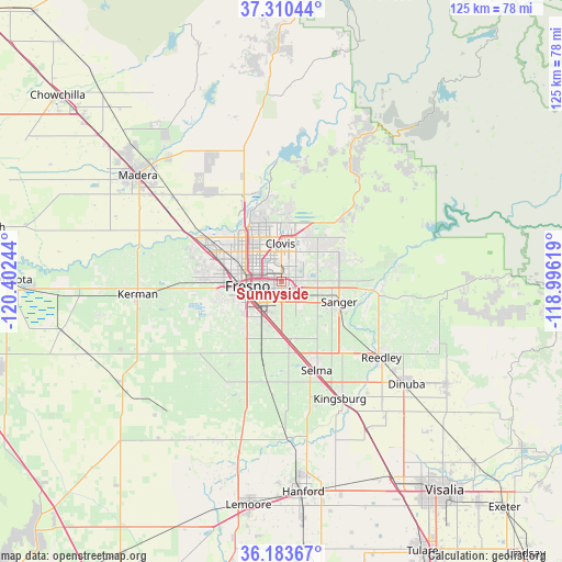
Sunnyside GPS coordinates[2]
36° 44' 56.832" North, 119° 41' 57.516" West
| Map corner | latitude | longitude |
|---|---|---|
| Upper-left | 37.31044°, | -120.40244° |
| Center: | 36.74912°, | -119.69931° |
| Lower-right: | 36.18367°, | -118.99619° |
| Map W x H: | 125.3×125.3 km | = 77.9×77.9mi |
| max Lat: | 71.29058° ⇑67.1% North |
| Sunnyside: | 36.74912° |
| min Lat: | ⇓32.9% South 19.06759° |
| min Long | Sunnyside | max Long |
| -171.73463° | -119.69931° | -66.98998° |
| W 7.4%⇐ | ⇒92.6% E |
Elevation
Elevation of Sunnyside is 101 m = 331 ft, and this is 193.8 m = 636 ft below average elevation for this country.
| Max E: |
3189 m = 10463 ft | 70% |
| Avg. | 294.8 m = 967 ft | |
| Sunnyside | 101 m = 331 ft | |
Min E: |
-60 m = -197 ft | 30% |
See also: United States elevation on elevation.city.
Geographical zone
Sunnyside is located in North temperate zone (between Tropic of Cancer and the Arctic Circle). Distance of this Northern Tropic circle is 1480.2 km =919.8 mi to South.| Distance of | km | miles | from Sunnyside |
|---|---|---|---|
| North Pole | 5920.9 | 3679.1 | to North |
| Arctic Circle | 3315.1 | 2059.9 | to North |
| Tropic Cancer | 1480.2 | 919.8 | to South |
| Equator | 4086.1 | 2539 | to South |


Nearby cities:
15 places around Sunnyside: (largest is in red/bold)
• Calwa
6.8 km =4.2 mi,  230°
230°
• Clovis
8.5 km =5.3 mi,  357°
357°
• Del Rey
13.7 km =8.5 mi,  136°
136°
• Easton
13.7 km =8.5 mi,  216°
216°
• Fowler
13.3 km =8.3 mi,  171°
171°
• Fresno
6.5 km =4 mi,  268°
268°
• Malaga
7.9 km =4.9 mi,  202°
202°
• Minkler
21.7 km =13.5 mi,  97°
97°
• Old Fig Garden
10.9 km =6.8 mi,  300°
300°
• Parlier
21.7 km =13.5 mi,  134°
134°
• Rolling Hills
19.2 km =11.9 mi,  332°
332°
• Sanger
13.6 km =8.5 mi,  109°
109°
• Selma
21.3 km =13.2 mi,  158°
158°
• Tarpey Village
4.9 km =3 mi, 358°
• West Park
14.2 km =8.8 mi,  252°
252°
Sources, notices
• [Note1] Compared only with cities in United States existing in our database
• [Src1] Map data: © OpenStreetMap contributors (CC-BY-SA)
• [Src2] Other city data from geonames.org with taken over terms of usage.
• [Src3] Geographical zone / Annual Mean Temperature by Robert A. Rohde @ Wikipedia
