Rolling Hills geodata
Rolling Hills (California) is a populated place; located in United States in America/Los_Angeles (GMT-7) time zone. With population of 742 people, there are 18286 cities with bigger population in this country. Compared to other cities in United States, 66.6% of cities are located further ↑North; 92.7% of cities are located further →East and 66.9% of cities have higher elevation than Rolling Hills. Note1


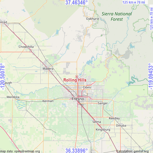
Rolling Hills GPS coordinates[2]
36° 54' 11.808" North, 119° 47' 51.54" West
| Map corner | latitude | longitude |
|---|---|---|
| Upper-left | 37.46346°, | -120.50078° |
| Center: | 36.90328°, | -119.79765° |
| Lower-right: | 36.33896°, | -119.09453° |
| Map W x H: | 125×125 km | = 77.7×77.7mi |
| max Lat: | 71.29058° ⇑66.6% North |
| Rolling Hills: | 36.90328° |
| min Lat: | ⇓33.4% South 19.06759° |
| min Long | Rolling Hills | max Long |
| -171.73463° | -119.79765° | -66.98998° |
| W 7.3%⇐ | ⇒92.7% E |
Elevation
Elevation of Rolling Hills is 118 m = 387 ft, and this is 176.8 m = 580 ft below average elevation for this country.
| Max E: |
3189 m = 10463 ft | 66.9% |
| Avg. | 294.8 m = 967 ft | |
| Rolling Hills | 118 m = 387 ft | |
Min E: |
-60 m = -197 ft | 33.1% |
See also: United States elevation on elevation.city.
Geographical zone
Rolling Hills is located in North temperate zone (between Tropic of Cancer and the Arctic Circle). Distance of this Northern Tropic circle is 1497.3 km =930.4 mi to South.| Distance of | km | miles | from Rolling Hills |
|---|---|---|---|
| North Pole | 5903.8 | 3668.5 | to North |
| Arctic Circle | 3297.9 | 2049.2 | to North |
| Tropic Cancer | 1497.3 | 930.4 | to South |
| Equator | 4103.3 | 2549.7 | to South |


Nearby cities:
15 places around Rolling Hills: (largest is in red/bold)
• Biola
22.5 km =14 mi,  239°
239°
• Bonadelle Ranchos-Madera Ranchos
11.3 km =7 mi,  322°
322°
• Calwa
21.7 km =13.5 mi,  170°
170°
• Clovis
12.1 km =7.5 mi,  135°
135°
• Fresno
17.4 km =10.8 mi, 172°
• Friant
12.1 km =7.5 mi,  39°
39°
• Madera
24.3 km =15.1 mi,  285°
285°
• Madera Acres
27.2 km =16.9 mi,  298°
298°
• Malaga
25.1 km =15.6 mi, 166°
• Old Fig Garden
11.6 km =7.2 mi,  183°
183°
• Parksdale
20.6 km =12.8 mi,  283°
283°
• Parkwood
22.1 km =13.7 mi, 276°
• Sunnyside
19.2 km =11.9 mi,  152°
152°
• Tarpey Village
15 km =9.3 mi, 144°
• West Park
22 km =13.7 mi,  192°
192°
Sources, notices
• [Note1] Compared only with cities in United States existing in our database
• [Src1] Map data: © OpenStreetMap contributors (CC-BY-SA)
• [Src2] Other city data from geonames.org with taken over terms of usage.
• [Src3] Geographical zone / Annual Mean Temperature by Robert A. Rohde @ Wikipedia
