Fresno geodata
Fresno (California) is a seat of a second-order administrative division; located in United States in America/Los_Angeles (GMT-7) time zone. With population of 520,052 people, there are 38 cities with bigger population in this country. Compared to other cities in United States, 67.1% of cities are located further ↑North; 92.6% of cities are located further →East and 70.3% of cities have higher elevation than Fresno. Note1


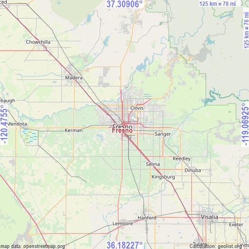
Fresno GPS coordinates[2]
36° 44' 51.828" North, 119° 46' 20.532" West
| Map corner | latitude | longitude |
|---|---|---|
| Upper-left | 37.30906°, | -120.4755° |
| Center: | 36.74773°, | -119.77237° |
| Lower-right: | 36.18227°, | -119.06925° |
| Map W x H: | 125.3×125.3 km | = 77.9×77.9mi |
| max Lat: | 71.29058° ⇑67.1% North |
| Fresno: | 36.74773° |
| min Lat: | ⇓32.9% South 19.06759° |
| min Long | Fresno | max Long |
| -171.73463° | -119.77237° | -66.98998° |
| W 7.4%⇐ | ⇒92.6% E |
Elevation
Elevation of Fresno is 99 m = 325 ft, and this is 195.8 m = 642 ft below average elevation for this country.
| Max E: |
3189 m = 10463 ft | 70.3% |
| Avg. | 294.8 m = 967 ft | |
| Fresno | 99 m = 325 ft | |
Min E: |
-60 m = -197 ft | 29.7% |
See also: Fresno elevation on elevation.city.
Geographical zone
Fresno is located in North temperate zone (between Tropic of Cancer and the Arctic Circle). Distance of this Northern Tropic circle is 1480 km =919.6 mi to South.| Distance of | km | miles | from Fresno |
|---|---|---|---|
| North Pole | 5921.1 | 3679.2 | to North |
| Arctic Circle | 3315.2 | 2060 | to North |
| Tropic Cancer | 1480 | 919.6 | to South |
| Equator | 4086 | 2538.9 | to South |


Nearby cities:
15 places around Fresno: (largest is in red/bold)
• Biola
22.5 km =14 mi,  285°
285°
• Calwa
4.3 km =2.7 mi,  163°
163°
• Caruthers
23.4 km =14.5 mi,  193°
193°
• Clovis
10.6 km =6.6 mi,  35°
35°
• Del Rey
18.7 km =11.6 mi,  121°
121°
• Easton
11 km =6.8 mi, 188°
• Fowler
15.5 km =9.6 mi,  147°
147°
• Malaga
7.9 km =4.9 mi, 154°
• Old Fig Garden
6.4 km =4 mi,  332°
332°
• Rolling Hills
17.4 km =10.8 mi,  352°
352°
• Sanger
19.8 km =12.3 mi,  102°
102°
• Selma
24.3 km =15.1 mi,  143°
143°
• Sunnyside
6.5 km =4 mi,  88°
88°
• Tarpey Village
8.1 km =5 mi,  51°
51°
• West Park
8.2 km =5.1 mi,  239°
239°
Sources, notices
• [Note1] Compared only with cities in United States existing in our database
• [Src1] Map data: © OpenStreetMap contributors (CC-BY-SA)
• [Src2] Other city data from geonames.org with taken over terms of usage.
• [Src3] Geographical zone / Annual Mean Temperature by Robert A. Rohde @ Wikipedia
