Clovis geodata
Clovis (California) is a populated place; located in United States in America/Los_Angeles (GMT-7) time zone. With population of 104,180 people, there are 331 cities with bigger population in this country. Compared to other cities in United States, 66.8% of cities are located further ↑North; 92.6% of cities are located further →East and 67.9% of cities have higher elevation than Clovis. Note1


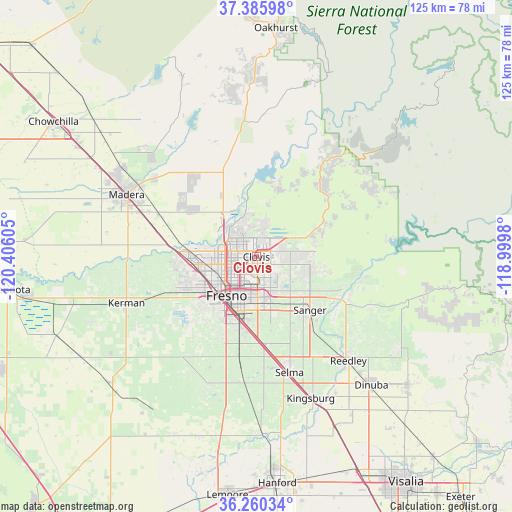
Clovis GPS coordinates[2]
36° 49' 30.828" North, 119° 42' 10.512" West
| Map corner | latitude | longitude |
|---|---|---|
| Upper-left | 37.38598°, | -120.40605° |
| Center: | 36.82523°, | -119.70292° |
| Lower-right: | 36.26034°, | -118.9998° |
| Map W x H: | 125.2×125.2 km | = 77.8×77.8mi |
| max Lat: | 71.29058° ⇑66.8% North |
| Clovis: | 36.82523° |
| min Lat: | ⇓33.2% South 19.06759° |
| min Long | Clovis | max Long |
| -171.73463° | -119.70292° | -66.98998° |
| W 7.4%⇐ | ⇒92.6% E |
Elevation
Elevation of Clovis is 113 m = 371 ft, and this is 181.8 m = 596 ft below average elevation for this country.
| Max E: |
3189 m = 10463 ft | 67.9% |
| Avg. | 294.8 m = 967 ft | |
| Clovis | 113 m = 371 ft | |
Min E: |
-60 m = -197 ft | 32.1% |
See also: Clovis elevation on elevation.city.
Geographical zone
Clovis is located in North temperate zone (between Tropic of Cancer and the Arctic Circle). Distance of this Northern Tropic circle is 1488.7 km =925 mi to South.| Distance of | km | miles | from Clovis |
|---|---|---|---|
| North Pole | 5912.5 | 3673.9 | to North |
| Arctic Circle | 3306.6 | 2054.6 | to North |
| Tropic Cancer | 1488.7 | 925 | to South |
| Equator | 4094.6 | 2544.3 | to South |


Nearby cities:
15 places around Clovis: (largest is in red/bold)
• Bonadelle Ranchos-Madera Ranchos
23.4 km =14.5 mi,  319°
319°
• Calwa
13.7 km =8.5 mi,  201°
201°
• Del Rey
20.9 km =13 mi,  152°
152°
• Easton
21 km =13 mi, 201°
• Fowler
21.8 km =13.5 mi,  174°
174°
• Fresno
10.6 km =6.6 mi,  215°
215°
• Friant
18.1 km =11.2 mi,  357°
357°
• Malaga
16 km =9.9 mi,  189°
189°
• Minkler
24.5 km =15.2 mi,  117°
117°
• Old Fig Garden
9.6 km =6 mi,  252°
252°
• Rolling Hills
12.1 km =7.5 mi, 315°
• Sanger
18.5 km =11.5 mi,  134°
134°
• Sunnyside
8.5 km =5.3 mi,  177°
177°
• Tarpey Village
3.6 km =2.2 mi, 177°
• West Park
18.4 km =11.4 mi,  225°
225°
Sources, notices
• [Note1] Compared only with cities in United States existing in our database
• [Src1] Map data: © OpenStreetMap contributors (CC-BY-SA)
• [Src2] Other city data from geonames.org with taken over terms of usage.
• [Src3] Geographical zone / Annual Mean Temperature by Robert A. Rohde @ Wikipedia
