San Joaquin geodata
San Joaquin (California) is a populated place; located in United States in America/Los_Angeles (GMT-7) time zone. With population of 4,022 people, there are 8193 cities with bigger population in this country. Compared to other cities in United States, 67.7% of cities are located further ↑North; 93% of cities are located further →East and 77.9% of cities have higher elevation than San Joaquin. Note1


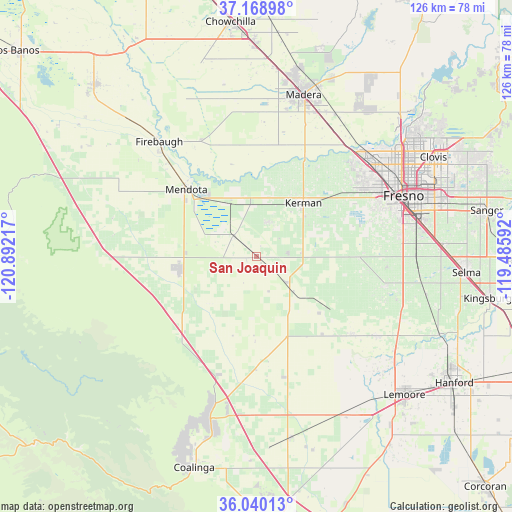
San Joaquin GPS coordinates[2]
36° 36' 23.832" North, 120° 11' 20.544" West
| Map corner | latitude | longitude |
|---|---|---|
| Upper-left | 37.16898°, | -120.89217° |
| Center: | 36.60662°, | -120.18904° |
| Lower-right: | 36.04013°, | -119.48592° |
| Map W x H: | 125.5×125.5 km | = 78×78mi |
| max Lat: | 71.29058° ⇑67.7% North |
| San Joaquin: | 36.60662° |
| min Lat: | ⇓32.3% South 19.06759° |
| min Long | San Joaquin | max Long |
| -171.73463° | -120.18904° | -66.98998° |
| W 7%⇐ | ⇒93% E |
Elevation
Elevation of San Joaquin is 56 m = 184 ft, and this is 238.8 m = 783 ft below average elevation for this country.
| Max E: |
3189 m = 10463 ft | 77.9% |
| Avg. | 294.8 m = 967 ft | |
| San Joaquin | 56 m = 184 ft | |
Min E: |
-60 m = -197 ft | 22.1% |
See also: United States elevation on elevation.city.
Geographical zone
San Joaquin is located in North temperate zone (between Tropic of Cancer and the Arctic Circle). Distance of this Northern Tropic circle is 1464.4 km =909.9 mi to South.| Distance of | km | miles | from San Joaquin |
|---|---|---|---|
| North Pole | 5936.8 | 3689 | to North |
| Arctic Circle | 3330.9 | 2069.7 | to North |
| Tropic Cancer | 1464.4 | 909.9 | to South |
| Equator | 4070.3 | 2529.2 | to South |


Nearby cities:
15 places around San Joaquin: (largest is in red/bold)
• Biola
26.6 km =16.5 mi,  35°
35°
• Calwa
40.1 km =24.9 mi,  73°
73°
• Caruthers
32.6 km =20.3 mi,  102°
102°
• Easton
35.9 km =22.3 mi,  82°
82°
• Firebaugh
36.8 km =22.9 mi,  319°
319°
• Fresno
40.3 km =25 mi, 67°
• Kerman
17.4 km =10.8 mi, 41°
• Lanare
30.3 km =18.8 mi,  130°
130°
• Mendota
23.7 km =14.7 mi,  313°
313°
• Old Fig Garden
40.3 km =25 mi,  58°
58°
• Parksdale
40.7 km =25.3 mi,  21°
21°
• Parkwood
37.9 km =23.5 mi, 19°
• Riverdale
35.3 km =21.9 mi,  123°
123°
• Tranquillity
7.4 km =4.6 mi, 309°
• West Park
32.3 km =20.1 mi, 69°
Sources, notices
• [Note1] Compared only with cities in United States existing in our database
• [Src1] Map data: © OpenStreetMap contributors (CC-BY-SA)
• [Src2] Other city data from geonames.org with taken over terms of usage.
• [Src3] Geographical zone / Annual Mean Temperature by Robert A. Rohde @ Wikipedia
