Easton geodata
Easton (California) is a populated place; located in United States in America/Los_Angeles (GMT-7) time zone. With population of 2,083 people, there are 11682 cities with bigger population in this country. Compared to other cities in United States, 67.5% of cities are located further ↑North; 92.7% of cities are located further →East and 72% of cities have higher elevation than Easton. Note1


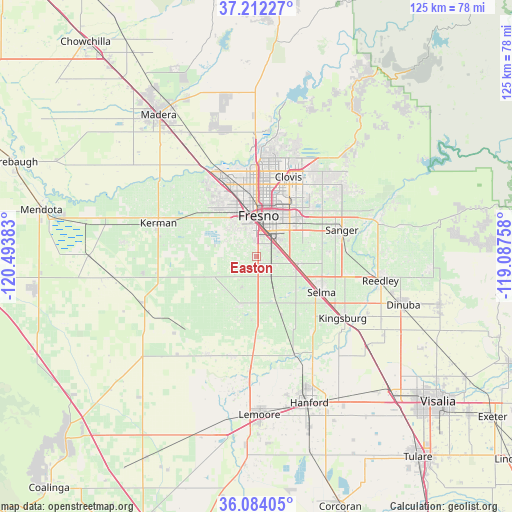
Easton GPS coordinates[2]
36° 39' 0.828" North, 119° 47' 26.52" West
| Map corner | latitude | longitude |
|---|---|---|
| Upper-left | 37.21227°, | -120.49383° |
| Center: | 36.65023°, | -119.7907° |
| Lower-right: | 36.08405°, | -119.08758° |
| Map W x H: | 125.4×125.4 km | = 77.9×77.9mi |
| max Lat: | 71.29058° ⇑67.5% North |
| Easton: | 36.65023° |
| min Lat: | ⇓32.5% South 19.06759° |
| min Long | Easton | max Long |
| -171.73463° | -119.7907° | -66.98998° |
| W 7.3%⇐ | ⇒92.7% E |
Elevation
Elevation of Easton is 89 m = 292 ft, and this is 205.8 m = 675 ft below average elevation for this country.
| Max E: |
3189 m = 10463 ft | 72% |
| Avg. | 294.8 m = 967 ft | |
| Easton | 89 m = 292 ft | |
Min E: |
-60 m = -197 ft | 28% |
See also: United States elevation on elevation.city.
Geographical zone
Easton is located in North temperate zone (between Tropic of Cancer and the Arctic Circle). Distance of this Northern Tropic circle is 1469.2 km =912.9 mi to South.| Distance of | km | miles | from Easton |
|---|---|---|---|
| North Pole | 5931.9 | 3685.9 | to North |
| Arctic Circle | 3326.1 | 2066.7 | to North |
| Tropic Cancer | 1469.2 | 912.9 | to South |
| Equator | 4075.1 | 2532.1 | to South |


Nearby cities:
15 places around Easton: (largest is in red/bold)
• Calwa
7.3 km =4.5 mi,  23°
23°
• Caruthers
12.5 km =7.8 mi,  197°
197°
• Clovis
21 km =13 mi, 21°
• Del Rey
17.6 km =10.9 mi,  86°
86°
• Fowler
10.3 km =6.4 mi,  102°
102°
• Fresno
11 km =6.8 mi,  8°
8°
• Malaga
6.3 km =3.9 mi,  53°
53°
• Old Fig Garden
16.6 km =10.3 mi,  355°
355°
• Parlier
23.9 km =14.9 mi, 100°
• Riverdale
25.1 km =15.6 mi,  194°
194°
• Sanger
21.9 km =13.6 mi,  72°
72°
• Selma
18.2 km =11.3 mi,  118°
118°
• Sunnyside
13.7 km =8.5 mi,  36°
36°
• Tarpey Village
17.8 km =11.1 mi,  26°
26°
• West Park
8.6 km =5.3 mi,  321°
321°
Sources, notices
• [Note1] Compared only with cities in United States existing in our database
• [Src1] Map data: © OpenStreetMap contributors (CC-BY-SA)
• [Src2] Other city data from geonames.org with taken over terms of usage.
• [Src3] Geographical zone / Annual Mean Temperature by Robert A. Rohde @ Wikipedia
