Kerman geodata
Kerman (California) is a populated place; located in United States in America/Los_Angeles (GMT-7) time zone. With population of 14,475 people, there are 3342 cities with bigger population in this country. Compared to other cities in United States, 67.2% of cities are located further ↑North; 92.9% of cities are located further →East and 74.9% of cities have higher elevation than Kerman. Note1


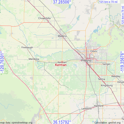
Kerman GPS coordinates[2]
36° 43' 24.816" North, 120° 3' 35.568" West
| Map corner | latitude | longitude |
|---|---|---|
| Upper-left | 37.28506°, | -120.76301° |
| Center: | 36.72356°, | -120.05988° |
| Lower-right: | 36.15792°, | -119.35676° |
| Map W x H: | 125.3×125.3 km | = 77.9×77.9mi |
| max Lat: | 71.29058° ⇑67.2% North |
| Kerman: | 36.72356° |
| min Lat: | ⇓32.8% South 19.06759° |
| min Long | Kerman | max Long |
| -171.73463° | -120.05988° | -66.98998° |
| W 7.1%⇐ | ⇒92.9% E |
Elevation
Elevation of Kerman is 72 m = 236 ft, and this is 222.8 m = 731 ft below average elevation for this country.
| Max E: |
3189 m = 10463 ft | 74.9% |
| Avg. | 294.8 m = 967 ft | |
| Kerman | 72 m = 236 ft | |
Min E: |
-60 m = -197 ft | 25.1% |
See also: United States elevation on elevation.city.
Geographical zone
Kerman is located in North temperate zone (between Tropic of Cancer and the Arctic Circle). Distance of this Northern Tropic circle is 1477.4 km =918 mi to South.| Distance of | km | miles | from Kerman |
|---|---|---|---|
| North Pole | 5923.8 | 3680.9 | to North |
| Arctic Circle | 3317.9 | 2061.6 | to North |
| Tropic Cancer | 1477.4 | 918 | to South |
| Equator | 4083.3 | 2537.2 | to South |


Nearby cities:
15 places around Kerman: (largest is in red/bold)
• Biola
9.6 km =6 mi,  23°
23°
• Calwa
26.9 km =16.7 mi,  93°
93°
• Caruthers
28.5 km =17.7 mi,  134°
134°
• Easton
25.3 km =15.7 mi,  108°
108°
• Fresno
25.8 km =16 mi,  84°
84°
• Madera
26.4 km =16.4 mi,  359°
359°
• Malaga
29.4 km =18.3 mi,  98°
98°
• Mendota
28.9 km =18 mi,  276°
276°
• Old Fig Garden
24.2 km =15 mi,  69°
69°
• Parksdale
25.1 km =15.6 mi,  7°
7°
• Parkwood
22.6 km =14 mi,  3°
3°
• Rolling Hills
30.7 km =19.1 mi,  49°
49°
• San Joaquin
17.4 km =10.8 mi,  221°
221°
• Tranquillity
19.1 km =11.9 mi,  244°
244°
• West Park
18.7 km =11.6 mi, 94°
Sources, notices
• [Note1] Compared only with cities in United States existing in our database
• [Src1] Map data: © OpenStreetMap contributors (CC-BY-SA)
• [Src2] Other city data from geonames.org with taken over terms of usage.
• [Src3] Geographical zone / Annual Mean Temperature by Robert A. Rohde @ Wikipedia
