California City geodata
California City (California) is a populated place; located in United States in America/Los_Angeles (GMT-7) time zone. With population of 13,277 people, there are 3604 cities with bigger population in this country. Compared to other cities in United States, 74.7% of cities are located further ↑North; 90.8% of cities are located further →East and 91.3% of cities have lower elevation than California City. Note1


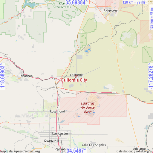
California City GPS coordinates[2]
35° 7' 32.88" North, 117° 59' 9.24" West
| Map corner | latitude | longitude |
|---|---|---|
| Upper-left | 35.69884°, | -118.68903° |
| Center: | 35.1258°, | -117.9859° |
| Lower-right: | 34.5487°, | -117.28278° |
| Map W x H: | 127.9×127.9 km | = 79.5×79.5mi |
| max Lat: | 71.29058° ⇑74.7% North |
| California City: | 35.1258° |
| min Lat: | ⇓25.3% South 19.06759° |
| min Long | California City | max Long |
| -171.73463° | -117.9859° | -66.98998° |
| W 9.2%⇐ | ⇒90.8% E |
Elevation
Elevation of California City is 737 m = 2418 ft, and this is 442.2 m = 1451 ft above average elevation for this country.
| Max E: |
3189 m = 10463 ft | 8.7% |
| California City | 737 m 2418 ft | |
| Avg. | 294.8 m = 967 ft | |
Min E: |
-60 m = -197 ft | 91.3% |
See also: United States elevation on elevation.city.
Geographical zone
California City is located in North temperate zone (between Tropic of Cancer and the Arctic Circle). Distance of this Northern Tropic circle is 1299.7 km =807.6 mi to South.| Distance of | km | miles | from California City |
|---|---|---|---|
| North Pole | 6101.4 | 3791.2 | to North |
| Arctic Circle | 3495.6 | 2172.1 | to North |
| Tropic Cancer | 1299.7 | 807.6 | to South |
| Equator | 3905.6 | 2426.8 | to South |


Nearby cities:
15 places around California City: (largest is in red/bold)
• Bear Valley Springs
58.5 km =36.4 mi,  273°
273°
• Boron
33.7 km =20.9 mi,  114°
114°
• China Lake Acres
60.7 km =37.7 mi,  19°
19°
• Desert View Highlands
61.4 km =38.2 mi,  194°
194°
• Edwards Air Force Base
23.7 km =14.7 mi,  168°
168°
• Golden Hills
45.9 km =28.5 mi, 272°
• Inyokern
60 km =37.3 mi, 15°
• Lake Los Angeles
58.9 km =36.6 mi, 165°
• Lancaster
49.5 km =30.8 mi,  196°
196°
• Mojave
19 km =11.8 mi,  244°
244°
• North Edwards
18.5 km =11.5 mi,  131°
131°
• Quartz Hill
57.5 km =35.7 mi, 201°
• Rosamond
33.3 km =20.7 mi,  209°
209°
• Stallion Springs
59.9 km =37.2 mi, 266°
• Tehachapi
42.1 km =26.2 mi, 270°
Sources, notices
• [Note1] Compared only with cities in United States existing in our database
• [Src1] Map data: © OpenStreetMap contributors (CC-BY-SA)
• [Src2] Other city data from geonames.org with taken over terms of usage.
• [Src3] Geographical zone / Annual Mean Temperature by Robert A. Rohde @ Wikipedia
