Silverton geodata
Silverton (Colorado) is a seat of a second-order administrative division; located in United States in America/Denver (GMT-6) time zone. With population of 637 people, there are 19293 cities with bigger population in this country. Compared to other cities in United States, 62.6% of cities are located further ↑North; 84.9% of cities are located further →East and 100% of cities have lower elevation than Silverton. Note1


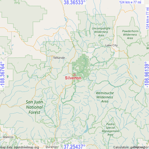
Silverton GPS coordinates[2]
37° 48' 42.984" North, 107° 39' 52.236" West
| Map corner | latitude | longitude |
|---|---|---|
| Upper-left | 38.36533°, | -108.36764° |
| Center: | 37.81194°, | -107.66451° |
| Lower-right: | 37.25437°, | -106.96139° |
| Map W x H: | 123.5×123.5 km | = 76.7×76.7mi |
| max Lat: | 71.29058° ⇑62.6% North |
| Silverton: | 37.81194° |
| min Lat: | ⇓37.4% South 19.06759° |
| min Long | Silverton | max Long |
| -171.73463° | -107.66451° | -66.98998° |
| W 15.1%⇐ | ⇒84.9% E |
Elevation
Elevation of Silverton is 2840 m = 9318 ft, and this is 2545.2 m = 8350 ft above average elevation for this country.
| Max E: |
3189 m = 10463 ft | 0% |
| Silverton | 2840 m 9318 ft | |
| Avg. | 294.8 m = 967 ft | |
Min E: |
-60 m = -197 ft | 100% |
See also: United States elevation on elevation.city.
Geographical zone
Silverton is located in North temperate zone (between Tropic of Cancer and the Arctic Circle). Distance of this Northern Tropic circle is 1598.4 km =993.2 mi to South.| Distance of | km | miles | from Silverton |
|---|---|---|---|
| North Pole | 5802.8 | 3605.7 | to North |
| Arctic Circle | 3196.9 | 1986.5 | to North |
| Tropic Cancer | 1598.4 | 993.2 | to South |
| Equator | 4204.3 | 2612.4 | to South |


Nearby cities:
15 places around Silverton: (largest is in red/bold)
• Bayfield
65.5 km =40.7 mi,  174°
174°
• Creede
65 km =40.4 mi,  86°
86°
• Dolores
83 km =51.6 mi,  243°
243°
• Durango
62.6 km =38.9 mi,  197°
197°
• Ignacio
77.5 km =48.2 mi,  177°
177°
• Lake City
39.1 km =24.3 mi,  51°
51°
• Loghill Village
43.8 km =27.2 mi,  346°
346°
• Mancos
75.7 km =47 mi,  226°
226°
• Montrose
76.4 km =47.5 mi, 345°
• Mountain Village
21.5 km =13.4 mi,  308°
308°
• Norwood
65.4 km =40.6 mi,  302°
302°
• Ouray
23.5 km =14.6 mi,  358°
358°
• Pagosa Springs
83.5 km =51.9 mi,  136°
136°
• Ridgway
38.8 km =24.1 mi, 347°
• Telluride
19.1 km =11.9 mi,  317°
317°
Sources, notices
• [Note1] Compared only with cities in United States existing in our database
• [Src1] Map data: © OpenStreetMap contributors (CC-BY-SA)
• [Src2] Other city data from geonames.org with taken over terms of usage.
• [Src3] Geographical zone / Annual Mean Temperature by Robert A. Rohde @ Wikipedia
