Loma geodata
Loma (Colorado) is a populated place; located in United States in America/Denver (GMT-6) time zone. With population of 1,293 people, there are 14621 cities with bigger population in this country. Compared to other cities in United States, 53.1% of cities are located further ↑North; 85.4% of cities are located further →East and 95.8% of cities have lower elevation than Loma. Note1


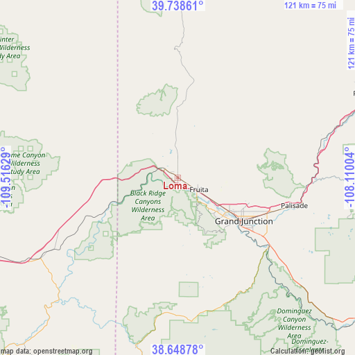
Loma GPS coordinates[2]
39° 11' 44.916" North, 108° 48' 47.376" West
| Map corner | latitude | longitude |
|---|---|---|
| Upper-left | 39.73861°, | -109.51629° |
| Center: | 39.19581°, | -108.81316° |
| Lower-right: | 38.64878°, | -108.11004° |
| Map W x H: | 121.2×121.2 km | = 75.3×75.3mi |
| max Lat: | 71.29058° ⇑53.1% North |
| Loma: | 39.19581° |
| min Lat: | ⇓46.9% South 19.06759° |
| min Long | Loma | max Long |
| -171.73463° | -108.81316° | -66.98998° |
| W 14.6%⇐ | ⇒85.4% E |
Elevation
Elevation of Loma is 1377 m = 4518 ft, and this is 1082.2 m = 3551 ft above average elevation for this country.
| Max E: |
3189 m = 10463 ft | 4.2% |
| Loma | 1377 m 4518 ft | |
| Avg. | 294.8 m = 967 ft | |
Min E: |
-60 m = -197 ft | 95.8% |
See also: United States elevation on elevation.city.
Geographical zone
Loma is located in North temperate zone (between Tropic of Cancer and the Arctic Circle). Distance of this Northern Tropic circle is 1752.2 km =1088.8 mi to South.| Distance of | km | miles | from Loma |
|---|---|---|---|
| North Pole | 5648.9 | 3510.1 | to North |
| Arctic Circle | 3043 | 1890.8 | to North |
| Tropic Cancer | 1752.2 | 1088.8 | to South |
| Equator | 4358.2 | 2708.1 | to South |


Nearby cities:
15 places around Loma: (largest is in red/bold)
• Battlement Mesa
73.1 km =45.4 mi,  68°
68°
• Cedaredge
83.3 km =51.8 mi,  113°
113°
• Clifton
33.5 km =20.8 mi, 110°
• Collbran
73.6 km =45.7 mi,  86°
86°
• Delta
81.7 km =50.8 mi,  128°
128°
• Fruita
8.3 km =5.2 mi,  119°
119°
• Fruitvale
30.1 km =18.7 mi, 114°
• Grand Junction
27 km =16.8 mi, 122°
• Moab
94.1 km =58.5 mi,  222°
222°
• Orchard City
83.5 km =51.9 mi, 119°
• Orchard Mesa
28.2 km =17.5 mi, 127°
• Palisade
41 km =25.5 mi,  103°
103°
• Parachute
71.3 km =44.3 mi, 66°
• Redlands
20.1 km =12.5 mi, 130°
• Rifle
96.2 km =59.8 mi, 66°
Sources, notices
• [Note1] Compared only with cities in United States existing in our database
• [Src1] Map data: © OpenStreetMap contributors (CC-BY-SA)
• [Src2] Other city data from geonames.org with taken over terms of usage.
• [Src3] Geographical zone / Annual Mean Temperature by Robert A. Rohde @ Wikipedia
