Hobbs geodata
Hobbs (New Mexico) is a populated place; located in United States in America/Denver (GMT-6) time zone. With population of 38,416 people, there are 1259 cities with bigger population in this country. Compared to other cities in United States, 86.4% of cities are located further ↑North; 82.3% of cities are located further →East and 94% of cities have lower elevation than Hobbs. Note1


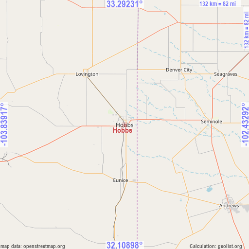
Hobbs GPS coordinates[2]
32° 42' 9.396" North, 103° 8' 9.744" West
| Map corner | latitude | longitude |
|---|---|---|
| Upper-left | 33.29231°, | -103.83917° |
| Center: | 32.70261°, | -103.13604° |
| Lower-right: | 32.10898°, | -102.43292° |
| Map W x H: | 131.6×131.6 km | = 81.8×81.8mi |
| max Lat: | 71.29058° ⇑86.4% North |
| Hobbs: | 32.70261° |
| min Lat: | ⇓13.6% South 19.06759° |
| min Long | Hobbs | max Long |
| -171.73463° | -103.13604° | -66.98998° |
| W 17.7%⇐ | ⇒82.3% E |
Elevation
Elevation of Hobbs is 1104 m = 3622 ft, and this is 809.2 m = 2655 ft above average elevation for this country.
| Max E: |
3189 m = 10463 ft | 6% |
| Hobbs | 1104 m 3622 ft | |
| Avg. | 294.8 m = 967 ft | |
Min E: |
-60 m = -197 ft | 94% |
See also: United States elevation on elevation.city.
Geographical zone
Hobbs is located in North temperate zone (between Tropic of Cancer and the Arctic Circle). Distance of this Northern Tropic circle is 1030.3 km =640.2 mi to South.| Distance of | km | miles | from Hobbs |
|---|---|---|---|
| North Pole | 6370.9 | 3958.7 | to North |
| Arctic Circle | 3765 | 2339.5 | to North |
| Tropic Cancer | 1030.3 | 640.2 | to South |
| Equator | 3636.2 | 2259.4 | to South |


Nearby cities:
15 places around Hobbs: (largest is in red/bold)
• Andrews
69.9 km =43.4 mi,  127°
127°
• Brownfield
96.4 km =59.9 mi,  56°
56°
• Denver City
40.9 km =25.4 mi,  44°
44°
• Eunice
29.6 km =18.4 mi,  184°
184°
• Gardendale
103.9 km =64.6 mi,  136°
136°
• Jal
65.8 km =40.9 mi, 184°
• Kermit
94 km =58.4 mi, 177°
• Loving
101.2 km =62.9 mi,  242°
242°
• Lovington
33.4 km =20.8 mi,  323°
323°
• McKinney Acres
72.3 km =44.9 mi, 128°
• Plains
61.2 km =38 mi,  28°
28°
• Seagraves
59.7 km =37.1 mi, 63°
• Seminole
46 km =28.6 mi,  87°
87°
• Sundown
103.2 km =64.1 mi, 35°
• Tatum
63.9 km =39.7 mi,  344°
344°
Sources, notices
• [Note1] Compared only with cities in United States existing in our database
• [Src1] Map data: © OpenStreetMap contributors (CC-BY-SA)
• [Src2] Other city data from geonames.org with taken over terms of usage.
• [Src3] Geographical zone / Annual Mean Temperature by Robert A. Rohde @ Wikipedia
