Clayton geodata
Clayton (New Mexico) is a seat of a second-order administrative division; located in United States in America/Denver (GMT-6) time zone. With population of 2,774 people, there are 10033 cities with bigger population in this country. Compared to other cities in United States, 68.2% of cities are located further ↑North; 82.3% of cities are located further →East and 97% of cities have lower elevation than Clayton. Note1


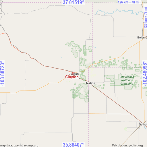
Clayton GPS coordinates[2]
36° 27' 6.084" North, 103° 11' 2.76" West
| Map corner | latitude | longitude |
|---|---|---|
| Upper-left | 37.01519°, | -103.88723° |
| Center: | 36.45169°, | -103.1841° |
| Lower-right: | 35.88407°, | -102.48098° |
| Map W x H: | 125.8×125.8 km | = 78.2×78.2mi |
| max Lat: | 71.29058° ⇑68.2% North |
| Clayton: | 36.45169° |
| min Lat: | ⇓31.8% South 19.06759° |
| min Long | Clayton | max Long |
| -171.73463° | -103.1841° | -66.98998° |
| W 17.7%⇐ | ⇒82.3% E |
Elevation
Elevation of Clayton is 1542 m = 5059 ft, and this is 1247.2 m = 4092 ft above average elevation for this country.
| Max E: |
3189 m = 10463 ft | 3% |
| Clayton | 1542 m 5059 ft | |
| Avg. | 294.8 m = 967 ft | |
Min E: |
-60 m = -197 ft | 97% |
See also: United States elevation on elevation.city.
Geographical zone
Clayton is located in North temperate zone (between Tropic of Cancer and the Arctic Circle). Distance of this Northern Tropic circle is 1447.1 km =899.2 mi to South.| Distance of | km | miles | from Clayton |
|---|---|---|---|
| North Pole | 5954 | 3699.6 | to North |
| Arctic Circle | 3348.1 | 2080.4 | to North |
| Tropic Cancer | 1447.1 | 899.2 | to South |
| Equator | 4053 | 2518.4 | to South |


Nearby cities:
15 places around Clayton: (largest is in red/bold)
• Boise City
67.4 km =41.9 mi,  62°
62°
• Cactus
114.9 km =71.4 mi,  112°
112°
• Channing
114.8 km =71.3 mi,  138°
138°
• Dalhart
74.3 km =46.2 mi,  125°
125°
• Dumas
126.7 km =78.7 mi,  120°
120°
• Elkhart
130.9 km =81.3 mi, 61°
• Hartley
94.6 km =58.8 mi, 131°
• Logan
122.5 km =76.1 mi,  189°
189°
• Mosquero
102.2 km =63.5 mi,  222°
222°
• Raton
122.7 km =76.2 mi,  294°
294°
• Springer
126.7 km =78.7 mi,  265°
265°
• Springfield
117.8 km =73.2 mi,  25°
25°
• Stratford
100.4 km =62.4 mi,  97°
97°
• Texhoma
125.4 km =77.9 mi,  87°
87°
• Texline
16.5 km =10.3 mi, 119°
Sources, notices
• [Note1] Compared only with cities in United States existing in our database
• [Src1] Map data: © OpenStreetMap contributors (CC-BY-SA)
• [Src2] Other city data from geonames.org with taken over terms of usage.
• [Src3] Geographical zone / Annual Mean Temperature by Robert A. Rohde @ Wikipedia
