Andrews geodata
Andrews (Texas) is a seat of a second-order administrative division; located in United States in America/Chicago (GMT-5) time zone. With population of 13,816 people, there are 3476 cities with bigger population in this country. Compared to other cities in United States, 87.7% of cities are located further ↑North; 82.1% of cities are located further →East and 93.2% of cities have lower elevation than Andrews. Note1


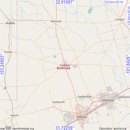
Andrews GPS coordinates[2]
32° 19' 7.392" North, 102° 32' 44.592" West
| Map corner | latitude | longitude |
|---|---|---|
| Upper-left | 32.91097°, | -103.24885° |
| Center: | 32.31872°, | -102.54572° |
| Lower-right: | 31.72258°, | -101.8426° |
| Map W x H: | 132.1×132.1 km | = 82.1×82.1mi |
| max Lat: | 71.29058° ⇑87.7% North |
| Andrews: | 32.31872° |
| min Lat: | ⇓12.3% South 19.06759° |
| min Long | Andrews | max Long |
| -171.73463° | -102.54572° | -66.98998° |
| W 17.9%⇐ | ⇒82.1% E |
Elevation
Elevation of Andrews is 969 m = 3179 ft, and this is 674.2 m = 2212 ft above average elevation for this country.
| Max E: |
3189 m = 10463 ft | 6.8% |
| Andrews | 969 m 3179 ft | |
| Avg. | 294.8 m = 967 ft | |
Min E: |
-60 m = -197 ft | 93.2% |
See also: United States elevation on elevation.city.
Geographical zone
Andrews is located in North temperate zone (between Tropic of Cancer and the Arctic Circle). Distance of this Northern Tropic circle is 987.6 km =613.7 mi to South.| Distance of | km | miles | from Andrews |
|---|---|---|---|
| North Pole | 6413.6 | 3985.2 | to North |
| Arctic Circle | 3807.7 | 2366 | to North |
| Tropic Cancer | 987.6 | 613.7 | to South |
| Equator | 3593.5 | 2232.9 | to South |


Nearby cities:
15 places around Andrews: (largest is in red/bold)
• Denver City
76.6 km =47.6 mi,  339°
339°
• Eunice
59.1 km =36.7 mi,  282°
282°
• Gardendale
36.6 km =22.7 mi,  154°
154°
• Hobbs
69.9 km =43.4 mi,  307°
307°
• Jal
65.1 km =40.5 mi,  249°
249°
• Kermit
72.7 km =45.2 mi,  225°
225°
• Lamesa
72.6 km =45.1 mi,  50°
50°
• McKinney Acres
2.4 km =1.5 mi,  140°
140°
• Midland
56.7 km =35.2 mi,  129°
129°
• Odessa
55.2 km =34.3 mi,  162°
162°
• Seagraves
69.6 km =43.2 mi,  358°
358°
• Seminole
45.5 km =28.3 mi,  348°
348°
• Stanton
74.3 km =46.2 mi,  106°
106°
• West Odessa
53.2 km =33.1 mi,  175°
175°
• Wink
85.6 km =53.2 mi,  222°
222°
Sources, notices
• [Note1] Compared only with cities in United States existing in our database
• [Src1] Map data: © OpenStreetMap contributors (CC-BY-SA)
• [Src2] Other city data from geonames.org with taken over terms of usage.
• [Src3] Geographical zone / Annual Mean Temperature by Robert A. Rohde @ Wikipedia
