Melrose geodata
Melrose (New Mexico) is a populated place; located in United States in America/Denver (GMT-6) time zone. With population of 644 people, there are 19229 cities with bigger population in this country. Compared to other cities in United States, 78% of cities are located further ↑North; 82.5% of cities are located further →East and 95.6% of cities have lower elevation than Melrose. Note1


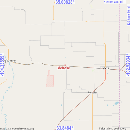
Melrose GPS coordinates[2]
34° 25' 49.26" North, 103° 37' 56.856" West
| Map corner | latitude | longitude |
|---|---|---|
| Upper-left | 35.00828°, | -104.33559° |
| Center: | 34.43035°, | -103.63246° |
| Lower-right: | 33.8484°, | -102.92934° |
| Map W x H: | 129×129 km | = 80.2×80.2mi |
| max Lat: | 71.29058° ⇑78% North |
| Melrose: | 34.43035° |
| min Lat: | ⇓22% South 19.06759° |
| min Long | Melrose | max Long |
| -171.73463° | -103.63246° | -66.98998° |
| W 17.5%⇐ | ⇒82.5% E |
Elevation
Elevation of Melrose is 1344 m = 4409 ft, and this is 1049.2 m = 3442 ft above average elevation for this country.
| Max E: |
3189 m = 10463 ft | 4.4% |
| Melrose | 1344 m 4409 ft | |
| Avg. | 294.8 m = 967 ft | |
Min E: |
-60 m = -197 ft | 95.6% |
See also: United States elevation on elevation.city.
Geographical zone
Melrose is located in North temperate zone (between Tropic of Cancer and the Arctic Circle). Distance of this Northern Tropic circle is 1222.4 km =759.6 mi to South.| Distance of | km | miles | from Melrose |
|---|---|---|---|
| North Pole | 6178.8 | 3839.3 | to North |
| Arctic Circle | 3572.9 | 2220.1 | to North |
| Tropic Cancer | 1222.4 | 759.6 | to South |
| Equator | 3828.3 | 2378.8 | to South |


Nearby cities:
15 places around Melrose: (largest is in red/bold)
• Bovina
69.3 km =43.1 mi,  82°
82°
• Cannon Air Force Base
28.5 km =17.7 mi,  97°
97°
• Clovis
39.3 km =24.4 mi,  94°
94°
• Earth
114.3 km =71 mi, 101°
• Farwell
54.8 km =34.1 mi, 95°
• Fort Sumner
56.4 km =35 mi,  274°
274°
• Friona
86.5 km =53.7 mi,  74°
74°
• Logan
105.9 km =65.8 mi,  11°
11°
• Morton
112.3 km =69.8 mi,  134°
134°
• Muleshoe
86.5 km =53.7 mi,  105°
105°
• Portales
38.6 km =24 mi, 134°
• Santa Rosa
111.4 km =69.2 mi,  300°
300°
• Sudan
109.5 km =68 mi, 111°
• Texico
53.5 km =33.2 mi, 94°
• Tucumcari
82.9 km =51.5 mi,  354°
354°
Sources, notices
• [Note1] Compared only with cities in United States existing in our database
• [Src1] Map data: © OpenStreetMap contributors (CC-BY-SA)
• [Src2] Other city data from geonames.org with taken over terms of usage.
• [Src3] Geographical zone / Annual Mean Temperature by Robert A. Rohde @ Wikipedia
