Bovina geodata
Bovina (Texas) is a populated place; located in United States in America/Chicago (GMT-5) time zone. With population of 1,769 people, there are 12671 cities with bigger population in this country. Compared to other cities in United States, 77.6% of cities are located further ↑North; 82.2% of cities are located further →East and 94.9% of cities have lower elevation than Bovina. Note1


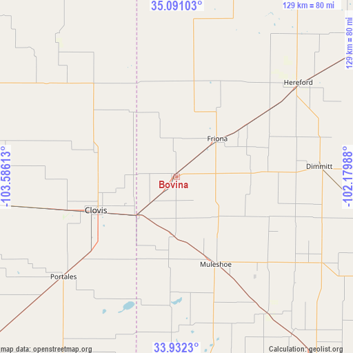
Bovina GPS coordinates[2]
34° 30' 49.248" North, 102° 52' 58.8" West
| Map corner | latitude | longitude |
|---|---|---|
| Upper-left | 35.09103°, | -103.58613° |
| Center: | 34.51368°, | -102.883° |
| Lower-right: | 33.9323°, | -102.17988° |
| Map W x H: | 128.8×128.8 km | = 80×80mi |
| max Lat: | 71.29058° ⇑77.6% North |
| Bovina: | 34.51368° |
| min Lat: | ⇓22.4% South 19.06759° |
| min Long | Bovina | max Long |
| -171.73463° | -102.883° | -66.98998° |
| W 17.8%⇐ | ⇒82.2% E |
Elevation
Elevation of Bovina is 1242 m = 4075 ft, and this is 947.2 m = 3108 ft above average elevation for this country.
| Max E: |
3189 m = 10463 ft | 5.1% |
| Bovina | 1242 m 4075 ft | |
| Avg. | 294.8 m = 967 ft | |
Min E: |
-60 m = -197 ft | 94.9% |
See also: United States elevation on elevation.city.
Geographical zone
Bovina is located in North temperate zone (between Tropic of Cancer and the Arctic Circle). Distance of this Northern Tropic circle is 1231.6 km =765.3 mi to South.| Distance of | km | miles | from Bovina |
|---|---|---|---|
| North Pole | 6169.5 | 3833.5 | to North |
| Arctic Circle | 3563.6 | 2214.3 | to North |
| Tropic Cancer | 1231.6 | 765.3 | to South |
| Equator | 3837.6 | 2384.6 | to South |


Nearby cities:
15 places around Bovina: (largest is in red/bold)
• Amherst
70.6 km =43.9 mi,  142°
142°
• Cannon Air Force Base
42.5 km =26.4 mi,  252°
252°
• Clovis
31.9 km =19.8 mi, 247°
• Dimmitt
52.5 km =32.6 mi,  85°
85°
• Earth
53.4 km =33.2 mi,  125°
125°
• Farwell
20.3 km =12.6 mi,  224°
224°
• Friona
20.4 km =12.7 mi,  45°
45°
• Hart
71.8 km =44.6 mi,  101°
101°
• Hereford
55.5 km =34.5 mi, 52°
• Melrose
69.3 km =43.1 mi,  262°
262°
• Muleshoe
35.1 km =21.8 mi,  155°
155°
• Olton
77.9 km =48.4 mi,  118°
118°
• Portales
55.2 km =34.3 mi,  228°
228°
• Sudan
59.5 km =37 mi,  146°
146°
• Texico
20.8 km =12.9 mi, 227°
Sources, notices
• [Note1] Compared only with cities in United States existing in our database
• [Src1] Map data: © OpenStreetMap contributors (CC-BY-SA)
• [Src2] Other city data from geonames.org with taken over terms of usage.
• [Src3] Geographical zone / Annual Mean Temperature by Robert A. Rohde @ Wikipedia
