Farwell geodata
Farwell (Texas) is a seat of a second-order administrative division; located in United States in America/Chicago (GMT-5) time zone. With population of 1,311 people, there are 14542 cities with bigger population in this country. Compared to other cities in United States, 78.2% of cities are located further ↑North; 82.3% of cities are located further →East and 95% of cities have lower elevation than Farwell. Note1


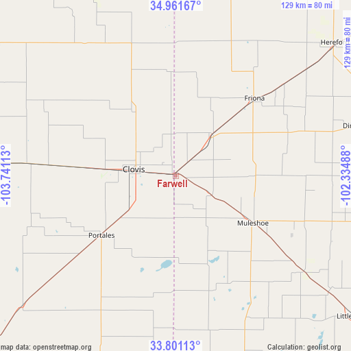
Farwell GPS coordinates[2]
34° 23' 0.276" North, 103° 2' 16.8" West
| Map corner | latitude | longitude |
|---|---|---|
| Upper-left | 34.96167°, | -103.74113° |
| Center: | 34.38341°, | -103.038° |
| Lower-right: | 33.80113°, | -102.33488° |
| Map W x H: | 129×129 km | = 80.2×80.2mi |
| max Lat: | 71.29058° ⇑78.2% North |
| Farwell: | 34.38341° |
| min Lat: | ⇓21.8% South 19.06759° |
| min Long | Farwell | max Long |
| -171.73463° | -103.038° | -66.98998° |
| W 17.7%⇐ | ⇒82.3% E |
Elevation
Elevation of Farwell is 1267 m = 4157 ft, and this is 972.2 m = 3190 ft above average elevation for this country.
| Max E: |
3189 m = 10463 ft | 5% |
| Farwell | 1267 m 4157 ft | |
| Avg. | 294.8 m = 967 ft | |
Min E: |
-60 m = -197 ft | 95% |
See also: United States elevation on elevation.city.
Geographical zone
Farwell is located in North temperate zone (between Tropic of Cancer and the Arctic Circle). Distance of this Northern Tropic circle is 1217.2 km =756.3 mi to South.| Distance of | km | miles | from Farwell |
|---|---|---|---|
| North Pole | 6184 | 3842.6 | to North |
| Arctic Circle | 3578.1 | 2223.3 | to North |
| Tropic Cancer | 1217.2 | 756.3 | to South |
| Equator | 3823.1 | 2375.6 | to South |


Nearby cities:
15 places around Farwell: (largest is in red/bold)
• Amherst
70.7 km =43.9 mi,  125°
125°
• Bovina
20.3 km =12.6 mi,  44°
44°
• Cannon Air Force Base
26.3 km =16.3 mi,  273°
273°
• Clovis
15.5 km =9.6 mi,  278°
278°
• Dimmitt
69.1 km =42.9 mi,  74°
74°
• Earth
60 km =37.3 mi,  106°
106°
• Friona
40.6 km =25.2 mi,  45°
45°
• Hereford
75.6 km =47 mi, 50°
• Littlefield
83.6 km =51.9 mi, 128°
• Melrose
54.8 km =34.1 mi, 275°
• Morton
77.6 km =48.2 mi,  160°
160°
• Muleshoe
33.7 km =20.9 mi,  121°
121°
• Portales
35 km =21.7 mi,  231°
231°
• Sudan
58.8 km =36.5 mi, 126°
• Texico
1.4 km =0.9 mi,  295°
295°
Sources, notices
• [Note1] Compared only with cities in United States existing in our database
• [Src1] Map data: © OpenStreetMap contributors (CC-BY-SA)
• [Src2] Other city data from geonames.org with taken over terms of usage.
• [Src3] Geographical zone / Annual Mean Temperature by Robert A. Rohde @ Wikipedia
