Portales geodata
Portales (New Mexico) is a seat of a second-order administrative division; located in United States in America/Denver (GMT-6) time zone. With population of 11,995 people, there are 3903 cities with bigger population in this country. Compared to other cities in United States, 79% of cities are located further ↑North; 82.4% of cities are located further →East and 94.7% of cities have lower elevation than Portales. Note1


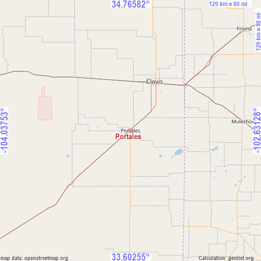
Portales GPS coordinates[2]
34° 11' 10.284" North, 103° 20' 3.84" West
| Map corner | latitude | longitude |
|---|---|---|
| Upper-left | 34.76582°, | -104.03753° |
| Center: | 34.18619°, | -103.3344° |
| Lower-right: | 33.60255°, | -102.63128° |
| Map W x H: | 129.3×129.3 km | = 80.3×80.3mi |
| max Lat: | 71.29058° ⇑79% North |
| Portales: | 34.18619° |
| min Lat: | ⇓21% South 19.06759° |
| min Long | Portales | max Long |
| -171.73463° | -103.3344° | -66.98998° |
| W 17.6%⇐ | ⇒82.4% E |
Elevation
Elevation of Portales is 1227 m = 4026 ft, and this is 932.2 m = 3058 ft above average elevation for this country.
| Max E: |
3189 m = 10463 ft | 5.3% |
| Portales | 1227 m 4026 ft | |
| Avg. | 294.8 m = 967 ft | |
Min E: |
-60 m = -197 ft | 94.7% |
See also: United States elevation on elevation.city.
Geographical zone
Portales is located in North temperate zone (between Tropic of Cancer and the Arctic Circle). Distance of this Northern Tropic circle is 1195.2 km =742.7 mi to South.| Distance of | km | miles | from Portales |
|---|---|---|---|
| North Pole | 6205.9 | 3856.2 | to North |
| Arctic Circle | 3600 | 2236.9 | to North |
| Tropic Cancer | 1195.2 | 742.7 | to South |
| Equator | 3801.1 | 2361.9 | to South |


Nearby cities:
15 places around Portales: (largest is in red/bold)
• Amherst
86.8 km =53.9 mi,  103°
103°
• Bovina
55.2 km =34.3 mi,  48°
48°
• Cannon Air Force Base
23.4 km =14.5 mi,  2°
2°
• Clovis
27 km =16.8 mi,  26°
26°
• Dimmitt
102.2 km =63.5 mi,  66°
66°
• Earth
85.1 km =52.9 mi,  86°
86°
• Farwell
35 km =21.7 mi, 51°
• Fort Sumner
89.5 km =55.6 mi,  290°
290°
• Friona
75.5 km =46.9 mi, 47°
• Littlefield
97.7 km =60.7 mi,  107°
107°
• Melrose
38.6 km =24 mi,  314°
314°
• Morton
73.8 km =45.9 mi,  134°
134°
• Muleshoe
56.3 km =35 mi, 85°
• Sudan
75.7 km =47 mi, 100°
• Texico
34.4 km =21.4 mi, 49°
Sources, notices
• [Note1] Compared only with cities in United States existing in our database
• [Src1] Map data: © OpenStreetMap contributors (CC-BY-SA)
• [Src2] Other city data from geonames.org with taken over terms of usage.
• [Src3] Geographical zone / Annual Mean Temperature by Robert A. Rohde @ Wikipedia
