Enterprise geodata
Enterprise (Nevada) is a populated place; located in United States in America/Los_Angeles (GMT-7) time zone. With population of 108,481 people, there are 313 cities with bigger population in this country. Compared to other cities in United States, 70.3% of cities are located further ↑North; 89% of cities are located further →East and 91.8% of cities have lower elevation than Enterprise. Note1


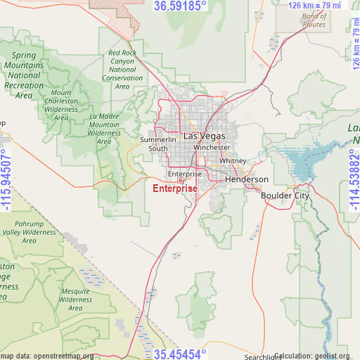
Enterprise GPS coordinates[2]
36° 1' 30.9" North, 115° 14' 30.984" West
| Map corner | latitude | longitude |
|---|---|---|
| Upper-left | 36.59185°, | -115.94507° |
| Center: | 36.02525°, | -115.24194° |
| Lower-right: | 35.45454°, | -114.53882° |
| Map W x H: | 126.5×126.5 km | = 78.6×78.6mi |
| max Lat: | 71.29058° ⇑70.3% North |
| Enterprise: | 36.02525° |
| min Lat: | ⇓29.7% South 19.06759° |
| min Long | Enterprise | max Long |
| -171.73463° | -115.24194° | -66.98998° |
| W 11%⇐ | ⇒89% E |
Elevation
Elevation of Enterprise is 779 m = 2556 ft, and this is 484.2 m = 1589 ft above average elevation for this country.
| Max E: |
3189 m = 10463 ft | 8.2% |
| Enterprise | 779 m 2556 ft | |
| Avg. | 294.8 m = 967 ft | |
Min E: |
-60 m = -197 ft | 91.8% |
See also: Enterprise elevation on elevation.city.
Geographical zone
Enterprise is located in North temperate zone (between Tropic of Cancer and the Arctic Circle). Distance of this Northern Tropic circle is 1399.7 km =869.7 mi to South.| Distance of | km | miles | from Enterprise |
|---|---|---|---|
| North Pole | 6001.4 | 3729.1 | to North |
| Arctic Circle | 3395.5 | 2109.9 | to North |
| Tropic Cancer | 1399.7 | 869.7 | to South |
| Equator | 4005.6 | 2489 | to South |


Nearby cities:
15 places around Enterprise: (largest is in red/bold)
• Boulder City
37.2 km =23.1 mi,  98°
98°
• Henderson
23.4 km =14.5 mi,  86°
86°
• Indian Springs
71.7 km =44.6 mi,  327°
327°
• Las Vegas
19.1 km =11.9 mi,  29°
29°
• Nellis Air Force Base
29.6 km =18.4 mi, 34°
• North Las Vegas
22.3 km =13.9 mi, 30°
• Pahrump
69.7 km =43.3 mi,  286°
286°
• Paradise
11.7 km =7.3 mi,  46°
46°
• Sandy Valley
42.1 km =26.2 mi,  236°
236°
• Searchlight
68.7 km =42.7 mi,  154°
154°
• Spring Valley
9.2 km =5.7 mi,  358°
358°
• Summerlin South
12.9 km =8 mi,  322°
322°
• Sunrise Manor
25.6 km =15.9 mi,  36°
36°
• Whitney
20.2 km =12.6 mi,  66°
66°
• Winchester
16.1 km =10 mi, 43°
Sources, notices
• [Note1] Compared only with cities in United States existing in our database
• [Src1] Map data: © OpenStreetMap contributors (CC-BY-SA)
• [Src2] Other city data from geonames.org with taken over terms of usage.
• [Src3] Geographical zone / Annual Mean Temperature by Robert A. Rohde @ Wikipedia
