Searchlight geodata
Searchlight (Nevada) is a populated place; located in United States in America/Los_Angeles (GMT-7) time zone. With population of 539 people, there are 20400 cities with bigger population in this country. Compared to other cities in United States, 72.9% of cities are located further ↑North; 88.9% of cities are located further →East and 93.9% of cities have lower elevation than Searchlight. Note1


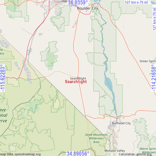
Searchlight GPS coordinates[2]
35° 27' 54.972" North, 114° 55' 10.92" West
| Map corner | latitude | longitude |
|---|---|---|
| Upper-left | 36.0359°, | -115.62283° |
| Center: | 35.46527°, | -114.9197° |
| Lower-right: | 34.89056°, | -114.21658° |
| Map W x H: | 127.3×127.3 km | = 79.1×79.1mi |
| max Lat: | 71.29058° ⇑72.9% North |
| Searchlight: | 35.46527° |
| min Lat: | ⇓27.1% South 19.06759° |
| min Long | Searchlight | max Long |
| -171.73463° | -114.9197° | -66.98998° |
| W 11.1%⇐ | ⇒88.9% E |
Elevation
Elevation of Searchlight is 1084 m = 3556 ft, and this is 789.2 m = 2589 ft above average elevation for this country.
| Max E: |
3189 m = 10463 ft | 6.1% |
| Searchlight | 1084 m 3556 ft | |
| Avg. | 294.8 m = 967 ft | |
Min E: |
-60 m = -197 ft | 93.9% |
See also: United States elevation on elevation.city.
Geographical zone
Searchlight is located in North temperate zone (between Tropic of Cancer and the Arctic Circle). Distance of this Northern Tropic circle is 1337.4 km =831 mi to South.| Distance of | km | miles | from Searchlight |
|---|---|---|---|
| North Pole | 6063.7 | 3767.8 | to North |
| Arctic Circle | 3457.8 | 2148.6 | to North |
| Tropic Cancer | 1337.4 | 831 | to South |
| Equator | 3943.4 | 2450.3 | to South |


Nearby cities:
15 places around Searchlight: (largest is in red/bold)
• Arizona Village
74.6 km =46.4 mi,  155°
155°
• Boulder City
57.6 km =35.8 mi,  7°
7°
• Bullhead City
47.6 km =29.6 mi,  137°
137°
• Dolan Springs
60.2 km =37.4 mi,  76°
76°
• Enterprise
68.7 km =42.7 mi,  334°
334°
• Golden Valley
68.7 km =42.7 mi,  113°
113°
• Henderson
64.1 km =39.8 mi,  354°
354°
• Laughlin
45.6 km =28.3 mi, 136°
• Mohave Valley
66.4 km =41.3 mi,  153°
153°
• Needles
74 km =46 mi, 157°
• Paradise
73.2 km =45.5 mi,  343°
343°
• Sandy Valley
75.3 km =46.8 mi,  301°
301°
• Whitney
71.2 km =44.2 mi, 351°
• Willow Valley
67.8 km =42.1 mi, 155°
• Winchester
76.1 km =47.3 mi, 346°
Sources, notices
• [Note1] Compared only with cities in United States existing in our database
• [Src1] Map data: © OpenStreetMap contributors (CC-BY-SA)
• [Src2] Other city data from geonames.org with taken over terms of usage.
• [Src3] Geographical zone / Annual Mean Temperature by Robert A. Rohde @ Wikipedia
