Las Vegas geodata
Las Vegas (Nevada) is a seat of a second-order administrative division; located in United States in America/Los_Angeles (GMT-7) time zone. With population of 623,747 people, there are 30 cities with bigger population in this country. Compared to other cities in United States, 69.6% of cities are located further ↑North; 89% of cities are located further →East and 89.8% of cities have lower elevation than Las Vegas. Note1


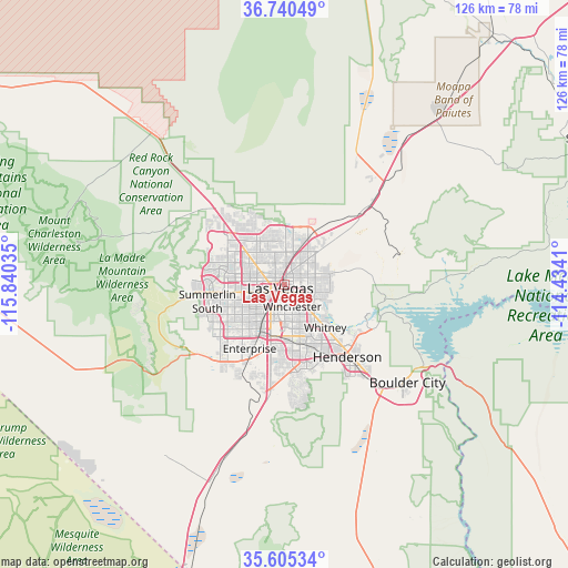
Las Vegas GPS coordinates[2]
36° 10' 29.892" North, 115° 8' 13.992" West
| Map corner | latitude | longitude |
|---|---|---|
| Upper-left | 36.74049°, | -115.84035° |
| Center: | 36.17497°, | -115.13722° |
| Lower-right: | 35.60534°, | -114.4341° |
| Map W x H: | 126.2×126.2 km | = 78.4×78.4mi |
| max Lat: | 71.29058° ⇑69.6% North |
| Las Vegas: | 36.17497° |
| min Lat: | ⇓30.4% South 19.06759° |
| min Long | Las Vegas | max Long |
| -171.73463° | -115.13722° | -66.98998° |
| W 11%⇐ | ⇒89% E |
Elevation
Elevation of Las Vegas is 613 m = 2011 ft, and this is 318.2 m = 1044 ft above average elevation for this country.
| Max E: |
3189 m = 10463 ft | 10.2% |
| Las Vegas | 613 m 2011 ft | |
| Avg. | 294.8 m = 967 ft | |
Min E: |
-60 m = -197 ft | 89.8% |
See also: Las Vegas elevation on elevation.city.
Geographical zone
Las Vegas is located in North temperate zone (between Tropic of Cancer and the Arctic Circle). Distance of this Northern Tropic circle is 1416.4 km =880.1 mi to South.| Distance of | km | miles | from Las Vegas |
|---|---|---|---|
| North Pole | 5984.8 | 3718.8 | to North |
| Arctic Circle | 3378.9 | 2099.6 | to North |
| Tropic Cancer | 1416.4 | 880.1 | to South |
| Equator | 4022.3 | 2499.3 | to South |


Nearby cities:
15 places around Las Vegas: (largest is in red/bold)
• Boulder City
35 km =21.7 mi,  128°
128°
• Enterprise
19.1 km =11.9 mi,  209°
209°
• Henderson
20.5 km =12.7 mi,  137°
137°
• Indian Springs
64.9 km =40.3 mi,  312°
312°
• Moapa Town
74.4 km =46.2 mi,  40°
40°
• Moapa Valley
74.8 km =46.5 mi,  52°
52°
• Nellis Air Force Base
10.7 km =6.6 mi, 42°
• North Las Vegas
3.2 km =2 mi,  33°
33°
• Paradise
8.7 km =5.4 mi,  185°
185°
• Sandy Valley
59.7 km =37.1 mi,  228°
228°
• Spring Valley
12.2 km =7.6 mi, 232°
• Summerlin South
18.5 km =11.5 mi,  249°
249°
• Sunrise Manor
7 km =4.3 mi,  55°
55°
• Whitney
12.4 km =7.7 mi, 133°
• Winchester
5.3 km =3.3 mi,  161°
161°
Sources, notices
• [Note1] Compared only with cities in United States existing in our database
• [Src1] Map data: © OpenStreetMap contributors (CC-BY-SA)
• [Src2] Other city data from geonames.org with taken over terms of usage.
• [Src3] Geographical zone / Annual Mean Temperature by Robert A. Rohde @ Wikipedia
